
Post 8912
Sinister Sparkle Gallery: 13 Mysterious & Cursed Gemstones
Haunting and Haute Histories

Diamonds and rubies and sapphires, oh my! Precious stones hold more than glitz and fame. They also hold mystery and intrigue. For instance, famous some are infamous for the misfortune they’re believed to attract to their owners.
Other gems are notorious for the myths surrounding their history, such as La Peregrina Pearl, which Elizabeth Taylor proudly showed off during her cameo of the 1969 film “Anne of a Thousand Days.” Take a journey through these gorgeous gemstones and the titillating tales they hold.
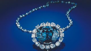
The Hope Diamond — The Curse of Debt
At 45.52 carats, the beautiful grayish-blue Hope Diamond is 1 inch (25.6 millimeters) in length and 0.8 inch (21.7 mm) in width. Its history traces back to the 17th-century diamond mines of Golconda, India, where it was first purchased in its original, crudely cut, 112.19-carat form by the French merchant Jean Baptiste Tavernier.
Tavernier sold the stone to King Louis XIV of France in 1668, who later had the stone re-cut and set in gold by the court jeweler. In 1792, after Louis XVI and Marie Antoinette attempted to flee France — their escape was foiled and they were guillotined in 1793 — the diamond was stolen during a looting of the French Royal Treasury, according to theSmithsonian Institution.
The diamond is believed to have then been owned by King George IV of England, but was sold after his death in 1830 to help settle his enormous debts. Thestone was then likely sold through private channels and was purchased by Henry Philip Hope, from whom it got its name. It was passed down to Hope’s family members until it was ultimately sold to help pay off their debts.
The stone was then bought by a London dealer, who quickly sold it to Joseph Frankels and Sons of New York City, who retained the diamond until they too had to sell it to cover debts. In 1909, Pierre Cartier bought the Hope Diamond and sold it to Evalyn Walsh McLean, an American mining heiress and socialite.
McLean had many misfortunes: her son died in a car accident, her daughter died of a drug overdose, her husband died in a sanitarium and her family was forced to sell their newspaper, the Washington Post, in a bankruptcy auction. After McLean’s death from pneumonia in 1947, Harry Winston Inc. purchased her entire jewelry collection.
In 1958, Winston donated the iconic Hope Diamond, which is worth a quarter of a billion dollars, to the Smithsonian Institution National Museum of Natural History in Washington, D.C., where it resides on display to this day.
As the museum states on its website, it “appears to have maintained the Hope curse-free.”
The Koh-i-Noor Diamond — Gentlemen Beware
Like the Hope Diamond, the 105.6-carat Koh-i-Noor diamond is believed to have been extracted from the Kollur mine in Golconda, India; its name in Persian means “mountain of light.”
Its first mention appears in the memoirs of Zahiruddin Muhammad Babur, the founder of the Mughal Empire in India. Babur wrote that the diamond was stolen from the Rajah of Malwa in 1306, and that it was a whopping 739 carats in its original, uncut form, according to the “Firefly Guide to Gems” (Firefly Books Ltd., 2003).
Throughout history, the gem traded hands among various Hindu, Mongolian, Persian, Afghan and Sikh rulers, who fought bitter and bloody battles to own it. According to folklore, a Hindu description of the Koh-i-Noor warns that “he who owns this diamond will own the world, but will also know all its misfortunes. Only God or woman can wear it with impunity.”
Historical records indicate the diamond was acquired by the British in 1849 and given to Queen Victoria in 1850. To heed its legend, the diamond has since only been worn by women, including Queen Alexandraof Denmark, Queen Mary of Teck and the late Queen Elizabeth, The Queen Mother, wife of King George VI.
Currently, it is set as one of the jewels within a British monarchy crown that is kept at the Tower of London Jewel House.The fight to possess the Koh-i-Noor is ongoing — India has been unsuccessfully lobbying to get the diamond back for years, while the British government maintains that it owns the gem fair and square, according to British Prime Minister David Cameron.
Black Prince’s Ruby — The Blood-Red “Great Impostor”
Black Prince’s ruby isn’t actually a ruby at all, but a large spinel — a hard, glassy mineral that crystallizes into various shades, including fiery red. Spinels are worth significantly less than rubies, which is why the Black Prince’s ruby is also known as “the great impostor.”
The ruby is believed to have been mined from Badakshan, which is present-day Tajikistan. It was first recorded during the 14th century, when it was plundered from the Moorish Kingdom of Granada by Don Pedro the Cruel, who was the ruler of Seville, Spain, according to “Fire and Blood: Rubies in Myth, Magic, and History,” (Greenwood Publishing Group, 2008)
The “ruby” was then owned by Edward of Woodstock, who was called “the Black Prince,” because of his success on the battlefield during the Hundred Years’ War. In 1415, King Henry V attained the Black Prince’s ruby and had it set in his battle helmet alongside real rubies. The king wore the helmet when he defeated the French forces at the Battle of Agincourt.
The gem was passed along to British royalty, including Henry VIII and his daughter, Elizabeth I, until King Charles I was beheaded for treason in 1649 and the stone was sold. Charles II bought the stone back from an unknown party, but nearly lost it when the infamous Irish colonel Thomas Blood attempted to steal the crown jewels of England from the Tower of London in 1671.
Currently, the Black Prince’s ruby is set dead-center at the front of the Imperial State Crown of England.
The Delhi Purple Sapphire — “Cursed” Quartz
The Delhi Purple sapphire is another imposter, because it isn’t really a sapphire, but an amethyst, which is a type of violet-hued quartz.
The mysterious stone is rumored to have been stolen by a British solider from the Temple of Indra, the Hindu god of war and weather, in Kanpur, India, during the Indian Mutiny of 1857. It was brought to England by Colonel W. Ferris, whose family then supposedly suffered many financial and health woes.
The stone was given to Edward Heron-Allen, a scientist and writer, in 1890, who claimed to have started having bad luck immediately after receiving it. He gave the amethyst away to friends, who were also struck with misfortune and quickly returned the gift back to him.
Heron-Allen warned that the Delhi Purple sapphire is “accursed and is stained with the blood, and the dishonor of everyone who has ever owned it.” Wary of its alleged powers, he kept it locked away in seven boxes and surrounded by good luck charms.
After his death, Heron-Allen’s daughter donated the amethyst to London’s Natural History Museum in 1943. Along with the stone, she gave them a letter that her father wrote cautioning future owners against directly handling it.
The mysterious Delhi Purple sapphire is now permanently on display as part of the Natural History Museum’s Vault Collection of precious gemstones.
La Peregrina Pearl — Tempestuous Token of Love
Elizabeth Taylor loved her gems — and one of her favorites was La Peregrina Pearl, a 50.6-carat pearl that is one of the largest found pearls in the world. It measures approximately 0.7 inch (17 millimeters) by 1 inch (25 mm).
La Peregrina means “the pilgrim” or “the wanderer” in Spanish, and the pearl was discovered in the Gulf of Panama during the 16th century. King Philip II of Spain gave the pearl to Queen Mary I of England before their marriage in 1554, but he later abandoned her and she died in 1558 without an heir. She was nicknamed “Bloody Mary” after her death because of the hundreds of Protestants she ordered to be executed during her five-year reign.
Following the queen’s death, La Peregrina Pearl was returned to King Philip II, who then proposed to Mary I’s younger half-sister, Elizabeth I. The pearl was worn by Spanish royalty until the 19th century, when Napoleon Bonaparte invaded and the French seized the Spanish crown — and the pearl.
La Peregrina Pearlwas passed down to members of the Bonaparte family, but was ultimately sold to Lord James Hamilton in 1873. It was then sold at a Sotheby’s auction in 1969 to Richard Burton, who gave it to his wife, Elizabeth Taylor, as a Valentine’s Day present. The couple married and divorced twice — with their second marriage lasting only nine months. Elizabeth Taylor held on to the pearl and married a total of eight times.
After Taylor’s death in 2011, La Peregrina Pearl was bought for 11.8 million by an anonymous buyer at a Christie’s auction, according to the auction house’s official site.
The Black Orlov — The Eye of Brahma Diamond
The Black Orlov, a 67.50-carat, cushion-cut diamond, wasunearthed in India during the early1800s. Despite its name, the Black Orlovis actually a deep, gunmetal gray in color.
According to lore surrounding the Black Orlov — which is similar to the supposed back-stories of many “cursed” gems — the diamond was stolen from asacred shrine in Southern India. The then-195-carat stone was allegedly removed from the eye of a statue of Brahma, the Hindu god of creation, wisdom and magic.
Legend has it the diamond was later acquired by the Russian princess Nadezhda Orlov, also known as Nadia Orlov, whom the stone was named after, according to “The Nature of Diamonds” (Cambridge University Press, 1998). It’s rumored that Princess Nadia, along with two of the Black Orlov’s other owners, upon attaining the diamond, committed suicide by jumping off of buildings, but these stories have not been substantiated.
In 1947, Charles F. Winson bought the diamond and cut it to its current size, also placing it in a setting surrounded by 108 diamonds and hanging it on a necklace of 124 diamonds. It has since been purchased and resold by a succession of private owners, and has been displayed at several museums, including the American Museum of Natural History in New York City and London’s Natural History Museum.
The Blue Diamond — A Source of Mystery
The Blue Diamond is the only precious stone whose current whereabouts are unknown — and whose existence has even been questioned. But it continues to be a source of bitter, ongoing drama.
The story begins in 1989, when a Thai janitor employed at the Saudi royal family’s palace crept into Prince Faisal bin Fahd’s bedroom and stole a large amount of jewelry, including a blue diamond that’s said to be bigger than the current dimensions of the Blue Diamond.
Allegedly, he hid the jewels in the bag of his vacuum cleaner, then smuggled them to Thailand, although Thai authorities maintain that there is no evidence that the Blue Diamond even exists. According to the Thai press, after Saudi authorities alerted Thai police of the crime, they captured the thief, but not before he sold off some of the jewels. He was sentenced to seven years in prison but was released after three.
Thai officials returned what was left of the loot to the royal family, who asserted that the Blue Diamond was still missing and that about half of the returned jewels were fakes. The murders and disappearances of several Saudi diplomats and businessmen who had flown to Bangkok to investigate the robbery have been linked to the so-called “Blue Diamond Affair,” but Thai authorities insist that there’s no proof that the events are connected.
In 1995, Chalor Kerdthes, the police officer in charge of the initial investigation, was sentenced to death for ordering the murder of the wife and 14-year-old son of the Thai jeweler who had been accused of making the imitation jewels. His sentence has since been reduced to 50 years, and the mysterious case of the Blue Diamond continues to strain Saudi-Thai diplomatic relations, according to an article published in The Economist in September 2010.
Because of all the deaths associated with the mysterious gem, the Blue Diamond is said place a curse onanyone who handles it illegally.
The Sancy Diamond — A Colorful History
The pear-shaped Sancy diamond may appear to be white, but it actually has a pale yellow tint. The 55.23-carat diamond is believed to have originated in India. Nicolas Harlay de Sancy, a French soldier who would later become a French Ambassador to Turkey, bought the diamond in 1570. He rented the diamond to Henry III of France in 1589, then to Henry IV.
In 1604, Sancy sold the diamond to James I of England, who wore the stone as a good luck charm. One legend tells that while the diamond was being transported by King Henry IV‘s men, the courier was robbed and murdered. He had swallowed the jewel to keep it safe, and theSancy was later recovered from his stomach during his autopsy, according to the myth.
The diamond disappeared during the French Revolution, when the Royal Treasury was raided and the Sancy was stolen, along with the Regent diamond and the Hope diamond. The Sancy resurfaced in 1828, when it was bought by the Russian prince Nicholas Demidoff, who passed it down to his son Paul.
A Bombay merchant then bought the diamond and exhibited it in Paris in 1867. It was sold toWilliam Waldorf Astor in 1906, and stayed in the family until 1978, when it was sold to the Louvre Museum in Paris. It’s now on exhibit at the museum’s Apollo Gallery, where it was reunited with the Regent diamond.
The Cullinan Diamond I — The Star of Africa Diamond
The Cullinan Diamond I comes from the world’s largest uncut diamond gem called the Cullinan.
The Orlov Diamond — Relic of a Failed Romance
Like the Black Orlov, the Orlov Diamond, which has a faint bluish-green tinge, is rumored to have once served as the eye of a Hindu god statue. The rose-cut diamond has a dome shape that resembles an egg that’s been cut in half. At 189.62 carats, the Orlov is one of the largest found diamonds in the world.
Legend has it that during the 18th century, a French solider stole it from a Hindu temple in Tamil Nadu, India. The Orlov (sometimes spelled Orloff), was then sold and resold until it ended up in Amsterdam, where it was bought by Grigory Grigoryevich Orlov, a Russian count.
Orlov had been having an affair with Catherine II while she was married to Peter III of Russia. Peter III was ultimately dethroned, Catherine subsequently became Catherine the Great of Russia and had an illegitimate child with Count Orlov. However, she ultimately left the count for a Russian prince, and the heartbroken Orlov gave her the giant diamond in an attempt to win back her affections.
Orlov’s grand romantic gesture was unsuccessful, but Catherine named the diamond after him and had it set in her royal scepter. Currently, the Orlov is part of the Kremlin Diamond Fund, an exhibit in Moscowshowcasing Russia’s crown jewels.
The Regent Diamond — The Pawned Pitt Diamond
The Regent Diamond was mined in 1701 in India and was 410 carats in its original, uncut form. Morbid myths surrounding the stone allege that it was found by a slave, who managed to conceal it inside a large, self-inflicted wound in his leg.
The myth states that after stealing the diamond from the mine, the slave conspired with an English sea captain to smuggle it away on his ship, but the captain then drowned the slave and sold the diamond, according to “Diamond Deposits: Origin, Exploration, and History of Discovery” (Society for Mining, Metallurgy, and Exploration, Inc., 2002).
An English governor named Thomas Pitt bought the diamond, which has a pale blue tint, and named it after himself. He had the diamond cut to its current size of 140.64 carats and sold it the French Regent Philippe II of Orleans in 1717. The diamond was renamed as the Regent, and the French royal family showed it off in several settings, including in the crown of King Louis XV.
In 1792, the Regent was stolen, but was located a few months later. The stone was later pawned to a Berlin jeweler to help raise funds for the French army, according to “Diamond Deposits.” Napoleon Bonaparte, also known as Napoleon I, claimed the diamond back in 1801, having it set in the handle of his sword.
Following Napoleon’s death in 1821, his widow, Archduchess Marie Louise of Austria, brought the diamond with her to Austria, but it was later returned to France as a present. The Regent then graced the crowns of Louis XVIII, Charles X and Napoleon III.
Currently, the diamond remains set in a diadem designed for the French Empress Eugenie, and is on display at the Louvre Museum in Paris, along with another gem on our list, the Sancy Diamond.
The Taylor-Burton — Bad Romance Diamond for a Good Cause
Another of Elizabeth Taylor‘s gems, the Taylor-Burton Diamond, which was mined in South Africa in 1966, was originally 240.80 carats; Harry Winston bought it and had it cut into its current 69.42-carat pear shape.
The diamond was put up for auction in 1969, and although actor Richard Burton bid on it, he was outbid by the owners of Cartier Inc., who paid a record price of $1,050,000 for the diamond and renamed it the Cartier Diamond. Determined, Burton worked out a six-figure deal with Cartier, purchasing the diamond from them under the condition that the company first display the stone in Cartier stores in New York and Chicago.
Burton then gave the diamond to Elizabeth Taylor for her 40th birthday during their first marriage. Originally, the massive sparkler was set in a ring, as shown in this still from the TV show “Here’s Lucy,” during an episode in which Taylor and Burton guest-starred. Taylor later commissioned Cartier to design and set the diamond in a necklace.
The couple renamed the stone the Taylor-Burton Diamond, and it served to represent their lavish lifestyle and larger-than-life relationship: the two allegedly fell in love while filming “Cleopatra” in 1963 — when they were both married to other people. The couple caused numerous tabloid frenzies throughout the years, with their relationship sometimes referred to as “the love affair of the century.”
Taylor proudly showed off the Taylor-Burton Diamond at movie premiers and events, including Princess Grace’s 40th birthday party in Monaco. After she and Burton divorced for the second time, Taylor auctioned off the rock in 1978 to an anonymous buyer from Saudi Arabia.
Reports of how much the diamond sold for range from $2 million to $5 million, but whatever the amount, Taylor used part of the proceeds to build a hospital in Botswana, Africa, at a site near where the diamond had been mined.
The Star Of India — The Stolen Star
The deep blue, oval star sapphire known as the Star of India weighs 563.35 carats. Unlike the other gemstones in this gallery, this star sapphire is a rounded, polished cabochon, rather than faceted.
The largest found blue sapphire in the world, the Star of India’s origin is believed to trace back to Sri Lanka, where it was discovered an estimated 300 years ago. The stone’s rare, characteristic star design occurred naturally. Tiny fibers of the mineral rutile aligned in a three-fold pattern within the gem, causing incoming light to reflect in a star pattern — an effect known as asterism.
In 1900, the Star of India was donated by industrialist J.P. Morgan to the American Museum of Natural History in New York. It was stolen from the museum in 1964, when a group of thieves left a bathroom window unlocked during the day and climbed in through the window at night.
At the time, the uninsuredStar of India was the only gem in the museum’s exhibit that was protected by an alarm, but as luck would have it, the alarm’s battery was dead, according to media reports. The men snatched the gem, along with several other precious stones that were on exhibit, and escaped back out the window.
The robbery was one of the biggest gem heists in American history, but the three thieves were captured within only two days. While some of the stolen gems were never seen again, theStar of India was miraculously recovered in a Miami bus station locker several months later.
The Star of India was put back on display at the American Museum of Natural History, where it remains on permanent display to this day — hopefully guarded by a more reliable alarm system.


