Merapi Continues to Take a Toll on Yogya’s Business Activities


Merapi Continues to Take a Toll on Yogya’s Business Activities.
By : Ririn Radiawati & Fidelis E. Satriastanti | November 15, 2010

The closure of Adisucipto Airport has meant drastically fewer tourists visiting Yogyakarta and attractions like Borobudur Temple. (AFP Photo)

The closure of Adisucipto Airport has meant drastically fewer tourists visiting Yogyakarta and attractions like Borobudur Temple. (AFP Photo)

With Yogyakarta’s airport now expected to remain shut until the end of the week because of the eruption of nearby Mount Merapi, the city is bracing for more bad times.

With an economy that relies heavily on tourism — more than 50 percent of visitors arrive by plane — Yogyakarta literally cannot afford to be without an airport. But dangerous ash particles and high winds mean flying in the area is not safe.

Herry Bakti Gumay, director general of air transportation at the Ministry of Transportation, said on Monday that Adisucipto International Airport would remain closed until Saturday.

The airport has been closed since Nov. 9 after a one-day closure from Nov. 5-6. Forty-two domestic and three international routes have been affected.

Herry said the decision to keep the airport closed until Saturday was reached by the Transportation Ministry after speaking with the Meteorological, Climatology and Geophysics Agency (BMKG). An advisory from the Volcanic Ash Advisory Center in Darwin, Australia, was also considered when making the decision.

“The Mount Merapi eruption is still going on at high intensity, with strong winds flowing to the west and south,” Herry said.

Although the air appeared to be clear, he added, the ash concentration was still high enough to disrupt the operation of jet engines.

“This ash is very smooth and if it gets into the engines, it could cause them to stall.

“There are certainly economic losses, but we are seeing this from a safety point of view,” he said.

“It could cause even bigger losses if the ash damaged the aircraft. In addition, we would lose international trust if we decided to reopen the airport even though conditions were still dangerous.”

But for local businesses, especially those that cater to the high-volume tourist trade, the reminders of safety and security are small comfort.

Many people in the tourism industry, including Syahrial Lubis, the sales and marketing director at the Hyatt Regency Hotel, had been pinning their hopes on a Tuesday reopening.

Yanti Sukamdani, chairwoman of the Indonesian Hotel and Restaurant Association, said last week that hotel occupancy rates in Yogyakarta had fallen to around 40 percent from the 80 percent level prior to the eruption.

Yogyakarta’s governor, Sri Sultan Hamengkubuwono X, has tried to reassure visitors that the city is still safe.

“As long as you don’t within the 20-kilometer range of Merapi’s red area,” he said.

Syahrial said that many tourists came to Yogyakarta after seeing Bali. “But now they are skipping here and choosing to stay in Bali,” he said.

Total Nusa, a tour and travel agency in Yogyakarta, has seen its customer volume almost halved this month. “We have had three postponed and two canceled tours this month,” said Rina, a branch marketing manager.

Merapi Farmers get Cash for Cows

POSTED BY REDSKY ON NOVEMBER – 18 – 2010

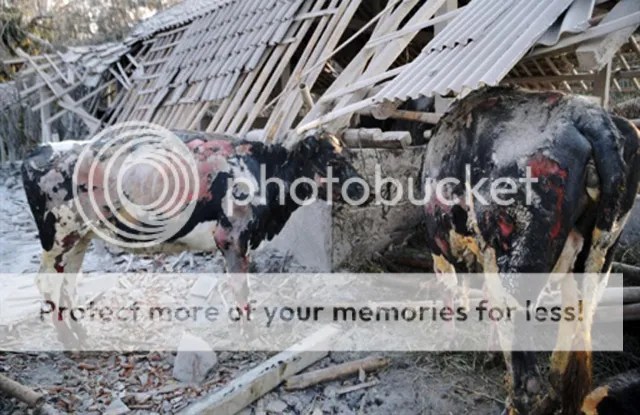
Yogyakarta. The government has started to purchase livestock from residents forced to evacuate from the slopes of the erupting Mount Merapi.

Mujilan, a resident of Hargobinangun village, in the Pakem subdistrict of Sleman in Yogyakarta, on Thursday became the first cattle owner to sell his cows to the government.

“Under normal conditions, the price of a cow could reach Rp 12 million [$1,350] per head. However, with there being a disaster, I was willing to sell the cows at Rp 10 million per head,” he said.

According to Mujilan, it was better to sell than risk his life looking for grass to feed his cattle.

The scheme is part of the government’s effort to help victims of the Merapi eruption while at the same time dissuading the evacuees from returning to the danger zone to tend to their cattle.

Keeping cattle for their milk and meat is one of the primary livelihoods in the area, particularly on the southern slopes of the mountain, which began to erupt on Oct 26.

Over 330,000 people have been evacuated from Sleman and the Central Java districts of Magelang, Boyolali and Klaten.

“Now I feel relieved and I can use the money from the sale of our cattle to survive,” he said.

Mujilan said he hoped he would still have some money remaining by the time the situation returned to normal so he could buy cattle again.

Suswono, the agriculture minister, said the government was opening 54 locations across Sleman district where cattle could be sold to the government.

“On the first day in Tlogoadi, we have bought 45 cattle, made up of 26 dairy cows, 10 non-dairy cows, and 9 calves. I hope the villagers will sell their livestock even though I know that some of them will choose to continue caring for the cows as a source of income. We are not forcing them [to sell their cattle],” he said.

According to the minister, there were 84,691 head of cattle within a radius of 20 kilometers from Merapi’s summit before the eruption. Of these, 10,231 had since been evacuated to 181 shelters, and 2,121 cattle had died.

“We have received 3,807 requests from refugees to buy their cows,” Suswono said.

He said the government had earmarked Rp 100 billion for the “cash for cows” scheme and fixed the price for each head of cattle at between Rp 5 million and Rp 10 million, depending on age and type.

Calves fetch the lowest price of Rp 5 million each, while oxen and non-dairy cows were bought for Rp 22,000 and Rp 20,000 per kilogram respectively.

Dairy cows are bought for Rp 10 million, while pregnant cows sell for Rp 9 million.

Suswono said the cows purchased from the villagers would be put out to pasture outside the 20-kilometer danger zone.

He said that villagers were also free to sell their cattle to private parties.

More Bodies Found at Mount Merapi

POSTED BY REDSKY ON NOVEMBER – 14 – 2010

Rescuers digging through several feet (a meter) of ash discovered nine more bodies on the slopes of Mount Merapi, whose explosive eruption a week ago buried whole villages.

As confirmation of more deaths trickled in Sunday, the toll from a series of blasts at the Indonesian volcano rose to at least 275.

The mountain, which has let off blasts of hot gas clouds over the past two days, resumed spewing ash on Sunday as it as done continuously since it roared to life Oct. 26. No new deaths have been reported from the latest flows, which were well within the zone that has been evacuated.

That zone — which has been at 12 miles (20 kilometers) for more than a week — was relaxed Sunday in some areas. In districts on the north and west flanks of the mountain, the cordon is now six miles (10 kilometers) from the crater, according to Muhammad Anshori, an official with the National Disaster Management Agency. He said the change reflected a feeling that these areas were safer.

Though there has been no major eruption since Nov. 5 — the deadliest day at Merapi in decades — tallying the dead from that blast has been slow.

Many villages where officials knew people had died have remained too hot — shrouded in drifts of ash several feet (a meter) deep — for rescuers to work. Conditions have improved in the past few days, pushing the death toll from the devastating eruption higher, said Waluyo Rahardjo, a search and rescue official.

Four bodies were pulled from the mountain Saturday and another five on Sunday, said Heru Trisna Nugraha, a spokesman for Sardjito hospital, at the foot of the volcano. In addition, one person in the blast died at the hospital, Negraha said.

The disaster agency’s official toll stood at 242 on Sunday, but the spokesman said that figure did not include at least eight of the 10 latest deaths because the data had not yet been officially passed on.

Merapi is the most active in Indonesia, a vast archipelago of 235 million people that is prone to seismic activity because it sits along the Pacific “Ring of Fire,” a horseshoe-shaped string of faults that lines the Pacific Ocean.


Updated Merapi Eruption November 17,2010


Death toll from Indonesia’s volcano climbs to 275

Mount Merapi spews volcanic material as seen ...

– Wed Nov 17, 11:01 pm ET

MOUNT MERAPI, Indonesia – The number of people killed by a series of eruptions at Indonesia’s most volatile volcano in recent weeks has risen to 275.

The National Disaster Management Agency said Thursday that the toll climbed after more than a dozen victims succumbed to their injuries — mostly severe burns.

Mount Merapi began unleashing torrents of hot gas, rock and other debris late last month after years of dormancy. The most significant blast came Nov. 5, the deadliest day at the mountain in decades.

The disaster agency said most of the 275 people were killed by searing gas clouds. Others died during panicked evacuations or from respiratory problems and other illnesses linked to the mountain.

Thousands of villagers returned to ash-covered homes along the slopes of Indonesia’s most volatile volcano Monday, after the government said some areas well away from the fiery crater appeared out of danger from another eruption.

Indonesians ignore volcano threat to go home

Dead cows lie are seen amid the ash and debris from the eruption of Indonesia’s Mount Merapi. Thousands of Indonesian families have returned to their village homes even as scientists warned the volcano remained a severe threat and more bodies were found buried in the ash.(AFP/File/Clara Prima)

Mount Merapi volcano spews ash as seen from Kali ...

Mount Merapi volcano spews ash as seen from Kali Tengah village in Sleman, near Yogyakarta November 15, 2010.

A soldier observes Mount Merapi from Cangkringan, ...

A soldier observes Mount Merapi from Cangkringan, Indonesia, Monday, Nov. 15, 2010.

Indonesians ignore volcano threat to go home

People watch as ash billows from Mount Merapi volcano on .

With their belongings piled on to motorcycles and pickup trucks, thousands of Indonesian families have returned home after fleeing the deadly volcanic eruptions.

(AFP/Roslan Rahman)

Infrared satellite image, where vegetation is ...

An image provided by Nasa on Nov. 15, 2010 is ...

An image provided by Nasa on Nov. 15, 2010 is a false-color satellite image from the ASTER instrument on NASA’s Terra satellite showing evidence of a large pyroclastic flow along the Gendol River south of Mount Merapi in Indonesia. Light gray volcanic deposits fill the course of the Gendol river south of the volcano. The dark ray area closer to the colcano is where a pyroclastic flow spread across the landscape, causing almost total devastation. Within this dark gray area, most of the trees were knocked down and the ground was coated by ash and rock.

(AP Photo/NASA)

A DigitalGlobe satellite image shows the eruption ...

A DigitalGlobe satellite image released to Reuters on November 15, 2010 shows the eruption and lava flow of Mount Merapi, Indonesia on November 12, 2010.

Satellite image shows the eruption and lava flow ...

Couple watch Mount Merapi volcano spew ash at ...

A couple watch Mount Merapi volcano spew ash at Kali Tengah village in Sleman, near Yogyakarta November 15, 2010. Mount Merapi volcano, on the outskirts of Yogyakarta city in central Java

Villagers walk on a field covered with volcanic ...

Villagers walk on a field covered with volcanic ash from the eruption of Mount Merapi in the village of Argomulya, in Sleman district in Central Java

A man walks by destroyed farm school covered ...

A man walks by destroyed farm school covered with volcanic ashes from the eruption of Mount Merapi in Cangkringan, Indonesia

Men run in the area covered with volcanic ashes ...

Volcanic ash from the eruption of Mount Merapi ...

Workers clear volcanic ash from the eruption ...

Workers clear volcanic ash from the eruption of Mount Merapi volcano covering the Borobudur Temple in Muntilan of Indonesia’s central Java

Indonesian workers walks near stupas of the famed ...

Indonesian workers walks near stupas of the famed Borobudur temple covered to protect them from volcanic ash from the eruption of Mount Merapi in Magelang, Indonesia

Indonesian workers cleans one of Buddha's statues ...

Indonesian workers cleans one of Buddha’s statues on the famed Borobudur temple in an effort to protect them from volcanic ash from the eruption of MountMerapi in Magelang, Indonesia,(AP Photo/Achmad Ibrahim)

Indonesian workers covers one of stupas on the ...

Indonesian workers covers one of stupas on the famed Borobudur temple to protect them from volcanic ash from the eruption of Mount Merapi in Magelang, Indonesia,

Indonesian workers clear volcanic ash from the ...

Indonesia volcano death toll rises to 240

Aerial view shows Mount Merapi volcano erupting ...

Mount Merapi volcano erupts, as seen from Manisrenggo ...

Mount Merapi spews volcanic material as seen ...

Mount Merapi spews volcanic material as seen from Argomulyo, Indonesia, Friday, Nov. 12, 2010.

(AP Photo/Achmad Ibrahim)

Mount Merapi spews volcanic material as seen ...

Eruption: Mount Merapi spews out towering clouds of gas and debris


Updated News of Merapi Eruption Monday 15, 2010


Updated News of Merapi Eruption Monday 15, 2010

Thousands of villagers returned to ash-covered homes along the slopes of Mount Merapi, Indonesia‘s most volatile volcano, today, after some areas appeared to be no longer at risk of another eruption.

The notoriously unpredictable volcano, in the centre of Java, roared back to life on 26 October, killing at least 259 people in a series of eruptions, according to the Indonesian national disaster management agency. Merapi was still rumbling and spewing searing ash and debristoday, said the state volcanologist Dr Surono, but activity has dropped sharply in recent days.

After spending nearly three weeks in crowded emergency camps, the villagers had headed up Mount Merapi loaded down with mats, blankets and clothes, only to find that almost everything they owned was gone, said Lilik Sujati, the chief of Jati, a village on Mount Merapi.

“Their houses are covered in thick ash; their crops can’t be harvested,” he said. “We need to find some way to help them. Many don’t have anything to eat.”

The Indonesian government has responded to the slowdown in volcanic activity by reducing the “danger zone” on the northern and western flanks of the crater from 12 miles to six miles. That has allowed some of the 390,000 evacuees to return home.

Merapi was still rumbling and spewing searing ash and debris Monday, said state vulcanologist Surono, but activity has dropped sharply in recent days.

Mount Merapi volcano spews ash as a villager collects her valuables from the ruins of her house at Kali Tengah village in Sleman, near Yogyakarta, on Monday.

Mount Merapi volcano spews ash as a villager collects her valuables from the ruins of her house at Kali Tengah village in Sleman, near Yogyakarta, on Monday. (Sigit Pamungkas/Reuters)

A soldier and volunteers walk as they search for victims of Mount Merapi's volcanic eruption at Glagaharjo village in Sleman, near Yogyakarta, on Monday.

A soldier and volunteers walk as they search for victims of Mount Merapi’s volcanic eruption at Glagaharjo village in Sleman, near Yogyakarta, on Monday. (Sigit Pamungkas/Reuters)

Mount Merapi eruption

foto

Dozens of people witnessed the cold lava of Merapi flooding River flooding the Code, in Danurejan, Yogyakarta. AFP PHOTO / Revelation Putro A

Mt Merapi eruptions cause monkey exodus

Boyolali (ANTARA News) – A few thousand monkeys had moved from the slopes of erupting Mount Merapi to those of Mount Merbabu in Central Java Province over the past week, a villager said. 

Parto told ANTARA News on Thursday that the exodus was likely triggered by the eruptions` impacts that had threatened those animals` food reserves.

This 80-year-old resident of Blumbangsari hamlet, Samiran village, Selo sub-district, Boyolali district, Central Java, said he always saw the monkeys crossing his village`s streets to the Mt Merbabu slopes.

Parto said those brown monkeys moved from their original habitat on the slopes of Mount Merapi to Mount Merbabu because they might have got problems with food reserves as a result of volcanic ash.

The monkeys were also likely unable to keep living with the heat of the smoldering Mount Merapi`s hot clouds of ash and lava, he said.

“The monkeys have been seen moving to the Mount Merbabu`s slopes over this past week. They cross the main road of Selo-Magelang route which has been part of the mountain`s areas,” he said.

Another villager named Slamet Sutanto, 40, said he also saw the exodus of Mount Merapi`s monkeys on the main road. Many crossed the road on their way to the Mount Merbabu`s slopes.

Those monkeys ate remaining fruits and vegetables available on the left and right sides of the road, he said.

According to Head of Mount Merbabu National Park Dulhadi, the exodus of Mount Merapi monkeys was triggered by the running out of food stocks in their habitat.

The heat of Mount Merapi`s hot clouds also forced them to find a new habitat, he said.
Mount Merapi, located on the border between two provinces, lies geographically close to Yogyakarta but is officially part of Central Java.

Besides killing and injuring several hundred people, the Mount Merapi eruptions had also damaged 867 hectares of forest on the volcano`s slopes in Sleman District, Yogyakarta, with the losses estimated at Rp33 billion.
The damaged forest areas consisted of Mt Merapi National Park, community forests and local people`s plantation areas.

Animal activist Daniek Hendarto said volunteers were providing animals with food and water. “We want to make sure the animals in the [20-kilometer] exclusion zone survive,” he said.

Pyroclastic flows, Sartono said, had also destroyed Javanese eagle nests in Kinahrejo and Kaliurang forests, forcing the birds to leave the area.

The sight of two leopards has also created panic among residents of Kemput village, in Sleman, 11 kilometers from Merapi’s crater. They said they saw the big cats approaching cow sheds.

“It looked like a mother and her cub,” said Sokidi of Kemput.

Several residents have remained at their village to guard their livestock, ignoring calls to evacuate as the village lies deep within the exclusion zone.

BKSDA and the management of Yogyakarta’s Gembira Loka Zoo announced plans to catch the leopards alive so they could be released later when conditions returned to normal.

Sartono said the BKSDA had also saved some wild animals, including an eagle. Animals endemic to the area, including the Javanese eagle, deer and birds, have also moved, but it is unclear to where, he added.

The eruptions are also believed to have changed the migratory patterns of certain bird species such as the Chinese sparrowhawk, besra, Japanese sparrowhawk and oriental honey buzzard.

“Before the eruptions I spotted some oriental honey buzzards over the area. I haven’t seen any since the eruptions,” bird spotter Chrismawan said.

The overall death toll in the past three weeks stood at 259 with more than 500 people injured. Many people were still missing in several hamlets, officials said.


Updated Merapi Eruption’s Report Saturday 13, 2010


Mount Merapi, seen from Sleman, Yogyakarta, continued to spew ash on Sunday, November 6. The ash forced dozens of international flights into Indonesia to be rescheduled.

A motorcyclist rides through an ash-covered village in Dukun, Central Java, on Thursday, November 11.

A man walks across the Lamat River in Dukun on Thursday Novembefr 11, the same day that disaster officials said the worst might be over. Even so, the alert level remained at 4, the highest.

Search-and-rescue team members from Yogyakarta carry a victim in Sleman on Monday, November 8.

Houses are covered with ash in Muntilan, Magelang, on Monday.

Evacuees fill a sport stadium used as an evacuation center in Sleman district Friday.

Volcanic ash covers vehicles Friday in Muntilan.

A woman cries after receiving treatment Friday from a paramedic at a temporary evacuation center in Yogyakarta

Many who live on Merapi’s slopes raise cattle and risked their lives by staying or returning to feed cows.

Relative attend the mass burial of the victims of Mount Merapi eruption in Umbulharjo, Yogyakarta,...

Volunteers carry the bodies of victims of Mount Merapi eruption at Kinarrejo village in Sleman

Volunteers carry the bodies of victims of Mount Merapi eruption at Kinarrejo village in Sleman

The death toll from the eruptions of Indonesia’s Mount Merapi rose to 240 Saturday November 13, 2010 as the search for more victims was ongoing, a disaster official said.

Indonesia volcano still shooting ash

AFP – A motorcyclist rides through a village covered with ash from the Mount Merapi eruption in Dukun. Indonesia’s …

by Anggoro Rullyanto

YOGYAKARTA, Indonesia (AFP) – Indonesia’s most active volcano sent clouds of ash high into the sky Thursday after a series of major eruptions, with an alert status remaining in force, an official said.

“Merapi’s intensity has slowed down, but small eruptions still occur and its status is still alert,” government volcanologist Raden Sukhyar said.

“The volcano still belches ash. It shot ash up to 1,000 metres high at 6:00 am today (2300 GMT Wednesday), but the ash had no potential to reach anywhere other than the slope of Merapi,” he said.

Since Mount Merapi began erupting in late October, a total of 194 people have died, according to Thursday’s updated toll, and more than 360,000 people have been forced to live in makeshift camps outside the danger zone.

As a result of Indonesia’s disasters in recent days, President Susilo Bambang Yudhoyono said he would curtail his attendance at two major international summits being held in East Asia this week.

Yudhoyono said he would attend only the second day of the G20 summit in Seoul, South Korea, on Friday and only the first day of APEC talks in Yokohama, Japan, on Saturday.

Indonesia has also been struck by a tsunami, which killed more than 400 people and left thousands homeless after an earthquake struck off Sumatra island on October 25, the day before Merapi erupted on central Java.

At a ninth-century Buddhist temple complex near Merapi, the site’s head of conservation said they would begin cleaning up the volcano’s fallout on Friday.

Borobudur, the country’s most popular tourist attraction, is only around 40 kilometres from Merapi and Marsis Sutopo said the site had been covered in ash from the eruptions.

“There is a layer of grey soot about two and half centimetres (one inch) thick covering Borobudur. We are worried the ash could soften the stones if we don’t clean them soon,” Sutopo said.

He said the clean-up would take about a week to complete.

The airport serving Yogyakarta, which lies around 25 kilometres (15 miles) south of the volcano, has been closed until Monday because of the ash.

Although there has been no report of volcanic ash clouding the area around Jakarta, 430 kilometres to the west, dozens of international flights to and from capital’s airport have also been cancelled for safety reasons.

Mount Merapi spews volcanic material as seen ...

Mount Merapi spews volcanic material as seen from Argomulyo, Indonesia, Thursday, Nov 11, 2010.

(AP Photo/Slamet Riyadi)
Indonesian soldiers search for victims killed ...
Rescuers search for victims of the eruption of ...

Rescuers search for victims of the eruption of Mount Merapi at Cangkringan, in Yogyakarta, Indonesia, Thursday, Nov. 11, 2010. Indonesia’s deadly volcanospit out towering clouds of ash but with clear skies over the capital, hundreds of miles (kilometers) to the west, international airlines resumed flights Thursday.« Read less

(AP Photo/Gembong Nusantara)
Rescuers search for victims of the eruption of ...
Rescuers search for victims of the eruption of Mount Merapi at Cangkringan, in Yogyakarta, Indonesia, on Thursday, Nov. 11, 2010
Volcanic ash from the eruption of Mount Merapi ...
Volcanic ash from the eruption of Mount Merapi covers the Borobudur temple in Magelang, Indonesia, Friday, Nov. 12, 2010.
Indonesian workers clear volcanic ash from the ...
Indonesian workers clear volcanic ash from the eruption of Mount Merapi covering the Borobudur temple in Magelang, Indonesia, Friday, Nov. 12, 2010.
Indonesian workers clear volcanic ash from the ...
Indonesian soldiers clean volcanic ash from the ...
Indonesian soldiers clean volcanic ash from the eruption of Mount Merapi covering Borobudur temple in Magelang, Indonesia, Thursday, Nov. 11, 2010.
Indonesian soldiers clean volcanic ash from the ...
Indonesian soldiers clean volcanic ash from the eruption of Mount Merapi covering Borobudur temple in Magelang, Indonesia, Thursday, Nov. 11, 2010.
A worker cleans up volcanic ash spewed from Mount ...
A Buddha statue is covered with volcanic ash ...
A man stands on a bridge overlooking a river ...
A man stands on a bridge overlooking a river carrying volcanic ash from the eruption of Mount Merapi in Magelang, Indonesia, Thursday, Nov. 11, 2010
A man clean his house  from volcanic ash from ...
A man clean his house from volcanic ash from the eruption of Mount Merapi at Ketep village in Magelang, Indonesia, Thursday, Nov. 11, 2010.
A man cleans the rooftop of his home from volcanic ...
A man cleans the rooftop of his home from volcanic ash spewed from Mount Merapi in Magelang, Indonesia
Volcanic ash from the eruption of Mount Merapi ...
Volcanic ash from the eruption of Mount Merapi covers Ketep village in Magelang, Indonesia, Thursday, Nov. 11, 2010.
Mount Merapi spews massive clouds of ash behind ...
Mount Merapi spews massive clouds of ash behind Prambanan temple in Klaten, Indonesia.
Members of a rescue team carry the body of a ...
Mount Merapi volcano erupts, as seen from Manisrenggo ...
Mount Merapi volcano erupts, as seen from Manisrenggo village in Klaten of Indonesia’s central Java province November 12, 2010.
Statues of Rama and Sinta are covered volcanic ...
Statues of Rama and Sinta are covered volcanic ash from the eruption of Mount Merapi at Muntilan, Magelang, Indonesia, Friday Nov. 12, 2010.
A man walk moves with his bike near statues covered ...
Aerial view shows Mount Merapi volcano erupting ...
Infrared satellite image, where vegetation is ...
Satellite image shows the eruption and lava flow ...
Indonesia volcano death toll rises to 240
A villager is seen walking on the volcanic debris from the Mount Merapi eruption which engulfed hamlets in Cangkringan, on November 13. Indonesia’s Mount Merapi volcano has killed 240 people since it began erupting late last month, with more than 390,000 people in makeshift camps, according to an official.
Merapi Volcano, Indonesia
On Friday ash emissions at Merapi volcano, Indonesia reached 1000 m above the summit. Moderate intensity roaring sounds were heard coming from the volcano. Small amount of ashfall was reported at Medari and Seyegan Kab. Sleman. Two pyroclastic flows were recorded. The first occurred at 12:54 with a duration of 3 minutes and a runout distance of 4 km towards K. Gendol and K. Talang. The second pyroclastic flow occurred at 17:38. Lahars down K. Boyong have reached villages 16 km from the summit Merapi. Satellite images show an ash plume extending 150 nautical miles SW of Merapi to a height of 25,000 ft.
Kali Code (Code River) – Jogyakarta critical condition because of  Materials/Lava/Sand  from Merapi eruption.

Death toll rises to 191 in Merapi eruptions


A man stands in his farm as he looks at volcanic ...

A man stands in his farm as he looks at volcanic ash rising from Mount Merapi in Magelang, Indonesia, Wednesday, Nov. 10, 2010. Continuous eruptions from an Indonesian volcano spewed clouds of ash into the skies Wednesday, forcing some international airlines to again cancel flights and U.S. President Barack Obama to cut short his visit

The eruption of Mount Merapi is seen from Prambanan ...

The eruption of Mount Merapi is seen from Prambanan temple in Sleman, Indonesia’s central Java province November 10, 2010. Mount Merapi showed lethargic signs on Wednesday but authorities would not lower down its alert status because of its intense seismic activities, the head of the country’s vulcanolology agency said.

Java search

Java search : A soldier from the Indonesian army special forces looks for victims of the Mount Merapi eruption at Ngepringan village in Sleman, centralJava.

Indonesian volcano death toll jumps to 191

Mount Merapi spews ash into the sky as seen from Cangkringan in Sleman, Yogyakarta. Ash from the eruption of Indonesia’s most active volcano, whichhas killed 191 people and displaced hundreds of thousands more, caused more disruption to flights on Wednesday.

Indonesian soldiers search for victims killed ...

Indonesian soldiers search for victims killed in the eruption of Mount Merapi in Cangkringan, Indonesia, Wednesday, Nov. 10, 2010. The volcano has forcedU.S. President Barack Obama to cut short his visit to the country, and some international airlines are canceling flights over concerns about air safety Wednesday.

Indonesian army soldiers carry the remains of ...

Indonesian army soldiers carry the remains of a victim killed by the eruption of Mount Merapi in Glagaharjo, Indonesia, Wednesday, Nov. 10, 2010.

(AP Photo)

Indonesia volcano wanes but some flights cancelled

Boys look at the eruption of Mount Merapi volcano in Manisrenggo village, in the Klaten district of Indonesia’s central Java province November 10,2010.« Read less

REUTERS/Andry Prasetyo

A woman works on her farm covered in volcanic ...

A woman works on her farm covered in volcanic ash from the eruption of Mount Merapi in Magelang, Indonesia, Wednesday, Nov. 10, 2010.

(AP Photo/Trisnadi)

Death toll rises to 191 in Merapi eruptions
Eruptive Mount Merapi
spacer November 11, 2010 – The death toll in Indonesia’s Mount Merapi eruptions risen to 191 on Wednesday as international airlines again cancel and postpone routes to and from the region. Disaster management officials confirmed the number of deaths since Merapi began making strong eruptions late last month. In addition, over 340,000 people are currently staying in temporary camps
Volcano alert status
· Check the most recent alert status of Gunung Merapi

· 11-11-2010: Death toll rises to 191 in Merapi eruptions

· 10-11-2010: photobook updated: Mount Merapi eruption 2010 (7 pictures added)

November 10, 2010 – A few moments later we made a short stop to see what we should do and decided to head on for a little longer. But less than a minute later we entered a village uphill via some sharp curves when all of a sudden one of the steep slopes of the Mount Merapi appeared in front of us. We stopped directly and heard absolutely nothing except a loud continuous thunder.
· 10-11-2010: The breathtaking view and sound of a pyroclastic cloud
· 10-11-2010: Mount Merapi still erupting, but less violent now

November 9, 2010 – The Sardjito general hospital in Yogyakarta has announced that they have listed over 200 missing persons after the most recent heavy eruptions of the Mount Merapi volcano in Central Java. Most of the missing were reported only after the most heavy eruption until now, which occurred last Friday.
· 09-11-2010: Over 200 missing after Mount Merapi eruptions

November 8, 2010 – Yesterday, after a night of rest without too much new activity of the Mount Merapi volcano, we left for that area soon after breakfast to see what happened outside the city of Yogyakarta. That this was much worse than inside the city was nothing to doubt about. How bad? That is something I didn’t know yet, because I had never had the chance to experience it.
· 08-11-2010: Mount Merapi victims buried in mass graves
· 08-11-2010: Muntilan turned into disaster zone

November 8, 2010 – After an heavy eruption of the Mount Merapi volcano three days ago, the search for dead and missing is still very difficult. The volcano is still very active and hot ash clouds like the one that came down the volcano’s slopes three days ago are still hitting the area around the volcano every few hours which causes circumstances to be very dangerous.
· 08-11-2010: Difficult search for missing and dead around Mount Merapi

November 7, 2010 – The total number of casualties caused by the ongoing eruption of the Mount Merapi volcano in Central Java has risen to 135. This was announced by a government agency earlier this afternoon, but it is very likely that this number will increase futher because several areas can not be searched and the volcano is showing no signs of cooling down.
· 07-11-2010: 135 dead and almost 300.000 evacuated over Mount Merapi eruption

November 6, 2010 – Just days before President Barack Obama’s visit to Indonesia, all international airlines canceled flights into the country’s capital city Saturday after a volcano hundreds of miles to the west unleashed its most powerful eruption in a century. The cancellation also means passengers leaving Jakarta for overseas had to call off their trips.
· 07-11-2010: Central Java train travel delayed by ash rains
· 07-11-2010: Lava from Mount Merapi’s latest eruption destroys two hamlets
· 06-11-2010: Jakarta declared no-fly zone after volcano eruption

November 6, 2010 – With Mount Merapi’s most recent eruption, which is being described as the worst in a century, the death toll has risen to 122, officials said Friday. Merapi’s thunderous roars late Thursday night were heard up to 25 kilometers away as it shot hot ash 10 kilometers into the sky and 11 kilometers down its slopes.
· 06-11-2010: Mount Merapi shows no sign of cooling down
· 06-11-2010: Death toll rises to 122 in Merapi eruptions

November 5, 2010 – The number of dead after the most recent eruption of the Mount Merapi volcano last night has risen to 89. The nightly eruption was the most heavy one since the eruption started a week and a half ago. The Coordinating Minister of Welfare, Agung Laksono, has confirmed this information earlier today.
· 05-11-2010: Volcanic material reaches rivers in Yogyakarta city
· 05-11-2010: Panic after renewed eruption of Mount Merapi volcano

· 05-11-2010: photobook updated: Mount Merapi eruption 2010 (7 pictures added)

November 5, 2010 – Panic broke out among the population after the most recent large eruption of the Mount Merapi volcano late in the evening. The chaos caused traffic problems in which at least two people died. A spokesperson of the Red Cross has confirmed this.
· 05-11-2010: Panic after renewed eruption of Mount Merapi volcano

November 4, 2010 – Indonesia’s Mount Merapi on Wednesday erupted again with more force than last week’s blasts, spewing out hot ash, lava, and burning rocks up to 5 kilometers into the sky for over an hour. Authorities expanded Merapi’s danger zone to 15 kilometers, which is beginning to reach areas not yet evacuated as well as refugee camps.
· 04-11-2010: Mount Merapi erupts again, danger zone expands
· 02-11-2010: Mount Merapi exhausted eight pyroclastic clouds today
· 02-11-2010: Mount Merapi erupts again


November 1, 2010 – Ash rains originating from the Mount Merapi volcano mixed with normal rain reached the city of Solo in the afternoon yesterday. The ash, originating from the most recent eruption of the volcano around 15:30 local time yesterday, forced the airport of Adi Soemarmo near Solo to close down for an hour.
· 01-11-2010Ash rains Mount Merapi reach Solo

· 31-10-2010: photobook updated: Mount Merapi eruption 2010 (13 pictures added)

· 30-10-2010: photobook: Mount Merapi eruption 2010 (13 pictures)

October 30, 2010 – After the most recent eruption of the Mount Merapi volcano in Central Java, the city of Yogyakarta was hit by ash rains. Houses and streets in a large part of the city are now covered in a thin layer of grayish white ash which measures several millimeters.
· 30-10-2010: Ash rains hit Yogyakarta city after latest eruption
· 29-10-2010: Death toll rises to 34 after Merapi eruptions

October 27, 2010 – One of Indonesia’s most active volcanoes spewed out clouds of ash and jets of searing gas on Wednesday in an eruption that has killed at least 28 people and injured 14. Authorities have been trying to evacuate more than 11,000 villagers living on the slopes of the volcano, where many houses have been destroyed, the ruins lying covered in white ash.
· 27-10-2010: At least 28 killed after Mount Merapi violently erupts

October 26, 2010 – Mount Merapi erupted on the Indonesian island of Java on late Tuesday afternoon, causing thousands of residents to flee the area, officials said. The eruption began at around 5.50 p.m. local time on Tuesday when three loud explosions rocked the mountain, spewing volcanic ashes into the sky.
· 26-10-2010: Thousands flee, some hurt as Mount Merapi erupts
· 26-10-2010: Mount Merapi threatens over 50,000 people on Java
· 25-10-2010: 40,000 people on Mount Merapi need to be evacuated

Thursday 11th November 2010
Merapi Volcano, Indonesia

Eruptions continue at Merapi volcano, Indonesia. Reduced activity occurred today up to 6am. Thundering sounds were heard from the volcano and light ashfall was reported. Ash emissions rose 700 m above the summit. Pyroclastic flows descended K. Gendol to a distance of 3 km. Ash deposits are located in all valleys on Southeast, South, Southwest, West and North West sectors of the volcano. A 20 km radius exclusion zone remains in place. Hazards at the volcano include pyroclastic flows, ashfall, and lahars. Merapi is at the highest level 4 alert.


Updated Merapi Eruption November 10, 2010


Updated Merapi Eruption November 10, 2010

Indonesia’s Mount Merapi volcano has killed 191 people since it began erupting late last month, with more than 340,000 people in makeshift camp

Media sources say that the volcano is still dangerous as eruptions and gas clouds continue to force people to abandon their houses with fear of another big eruption. The end is not yet in sight

Latest reports state that 279,000 people are displaced. The total population affected is 4 million. The danger zone has been extended to 20 km around Merapi’s crater.

Merapi erupts: Borobudur Temple became Grey

Borobudur Temple became Grey.

07 November 2010 | BP

Borobudur Temple in Magelang regency, Central Java, on Saturday (6 / 11) yesterday, closed the volcanic ash of Mount Merapi. This tourist attraction was closed to tourist visits since Friday (5 / 11) then. This is done along with the thick rain of volcanic ash from eruption of Mount Merapi in the last two days.

Head of Borobudur Tourism Park unit, Pujo Suwarno, said layer of ash that stuck to the rock temple during the first eruption of Merapi only a few millimeters. Now, the thickness was more than two centimeters. Almost the entire surface of the rock temples gray,”he said.

On October 26 to 30 layers of ash has not reached 2 cm, the area of Borobudur temple which was closed to tourist visits only part of the floor (step) three to ten. Tourists can still get around on the floor one and two.

Besides covering the rock temple, Merapi volcanic ash also cover parks and trees around the temple. Stems of these plants were broken and limp due to not hold the load of ash mixed with water. This condition could endanger the safety of visitors.

According to the Pujo, Borobudur is also less convenient because the pages visited and the building of the temple muddy muddy. Roads in the complex”Borobudur Tourism Park today is very slippery so feared making visitors will easily slip,”he said.

While it was decided the Borobudur Temple was closed for three days. After that, said Pujo, will be reconsidered, whether the closure was extended or not.

Since going eruption of Merapi, Borobudur tourist numbers, both from foreign and domestic, declined dramatically. (KMB)

Borobudur Temple.

Borobudur Temple.

Borobudur Temple.

Taman Wisata Candi Borobudur Rusak Berat

Merapi Masih Erupsi Hingga Saat Ini

Merapi Eruption November 10, 2010

PMI Terjunkan Hagglunds Untuk Evakuasi ...


2010 eruptions of Mount Merapi The last Updated


2010 eruptions of Mount Merapi

From Wikipedia, the free encyclopedia

This article documents a current event. Information may change rapidly as the event progresses.

The 2010 eruptions of Mount Merapi began in late October 2010 when Mount Merapi in Central JavaIndonesia began an increasingly violent series of eruptions that continued into November. Seismic activity around the volcano increased from mid-September onwards, culminating in repeated outbursts lava and ashes. Largeeruption columns formed, causing numerous pyroclastic flows down the heavily populated slopes of the volcano. Merapi’s eruption was said by authorities to be the largest since the 1870s.

Over 100,000 people were evacuated from the affected area. However, many remained behind or returned to their homes before the eruption had finished. Over a hundred people were killed during the eruption, many as a result of pyroclastic flows. The eruption also caused major disruption to aviation across Java, due to the ash plumes.[2][3]

Volcanic eruptions

Recent background

The thermal signature of hot ash and rock and a glowing lava dome on Mount Merapi.

In late October 2010 the Center for Volcanology and Geological Hazard Mitigation, Geological Agency (CVGHM), (Pusat Vulkanologi & Mitigasi Bencana Geologi, Badan Geologi-PVMBG), reported that a pattern of increasing seismicity from Merapi had begun to emerge in early September. Observers at Babadan 7 kilometres (4.3 mi) west and Kaliurang8 kilometres (5.0 mi) south of the mountain reported hearing an avalanche on 12 September 2010. On 13 September 2010 white plumes were observed rising 800 metres (2,600 ft) above the crater. Lava dome inflation, detected since March, increased from background levels of 0.1 millimetres (0.0039 in) to 0.3 millimetres (0.012 in) per day to a rate of 11 millimetres (0.43 in) per day on 16 September. On 19 September 2010 earthquakes continued to be numerous, and the next day CVGHM raised the Alert Level to 2 (on a scale of 1–4).[4] Lava from Mount Merapi began flowing down the Gendol River on 23–24 October signalling the likelihood of an imminent eruption.[5]

On 25 October 2010 the Indonesian government raised the alert for Mount Merapi to its highest level (4) and warned villagers in threatened areas to move to safer ground. People living within a 10 kilometres (6.2 mi) zone were told to evacuate. The evacuation orders affected at least 19,000 people however the number that complied at the time remained unclear to authorities.[6] Officials said about 500 volcanic earthquakes had been recorded on the mountain over the weekend of 23–24 October, and that the magma had risen to about a 1 kilometre (3,300 ft) below the surface due to the seismic activity[7]

Chronology of eruptive events

Monday, 25 October

Fears for missing children in Indonesia volcano ...

Merapi erupted three times on Monday afternoon spewing lava down its southern and south-eastern slopes. Three major eruptions were recorded at 14:04, 14:24 and 15:15 local time.[8] On this day, 222 volcanic seismic events and 454 avalanche seismic events were recorded by Center for Volcanology and Geological Hazard Mitigation monitoring staff at Merapi.[9]

Tuesday, 26 October

The eruptions on Tuesday started at 17:02. By 18:54 pyroclastic activity had begun to subside following 12 eruption-associated events being recorded by CVGHM monitors. In the 24 hours of 26 October, 232 volcanic seismic events, 269 avalanche seismic events, 4 lava flow seismic events and 6 heat clouds were recorded. The eruptive events were classified as explosive eventswith volcanic bursts of ejected material, visible flame and pyroclastic hot air flows. A column of smoke rose from the top to a vertical distance of 1.5 kilometres (4,900 ft) from the summit of Mount Merapi.[9] The first fatalities occurred on this day.

Friday, 29 October

On Friday eruptive activity included lava ejection with hot ash clouds reported to be flowing 3 kilometres (1.9 mi) down the slopes of the mountain and lasting four to nine minutes. Ash falls reached as far as the Central Java town of Magelang. Scientists monitoring the volcano includingSurono, chief of the Volcanology and Geological Disaster Mitigation Center (PVMBG), expressed optimism that the volcanic activity should decrease following the release of lava. Safari Dwiyono, a scientist monitoring Mt. Merapi for 15 years, said the volcanic activity appeared to be easing pressure behind a lava dome that had formed in the crater.[10][11] The International Red Cross reported that On 29 October, from 07:23 to 21:40, pyroclastic flow from Merapi struck Lamat River, Senowo River, and Krasak River.[12]

Saturday, 30 October

By early on the morning of Saturday 30 October the volcano was erupting again. Sri Sumarti, head of the Merapi section at the Volcano Investigation and Technology Development Institution (BPPTK), reported the eruptions were louder and stronger than those of 26 October. Ash from the eruptions on 30 October fell more than 30 kilometres (19 mi) away and now included ash falls upon the city ofYogyakarta. Soldiers and police posted nearest the volcano were seen fleeing along with hundreds of residents who quickly clogged roads with cars and motorcycles. Black soot fell across a vast area. The morning eruptions lasted for 22 minutes while heat clouds flowed into the Krasak and Boyong Rivers and rose 3.5 kilometres (11,000 ft) into the air, drifting westward toward Magelang. Yogyakarta’s Adisucipto Airport was closed temporarily between 05:00 to 07:00. Later that day, Subandrio, head of the BPPTK suggested there would be further eruptions as magma continued to push its way up into the volcano’s lava dome.[13][14] A pyroclastic river flowed from Merapi again on 30 October 2010 at 00:35. A pyroclastic flow headed toward Gendol River, Kuning River, Krasak River, and Boyong River. This was then followed by an explosion from Merapi resulting in a two kilometer vertical high fire ball rising from the top of the mountain . This eruption caused raining sand to fall on areas to a radius of up to 10 kilometres (6.2 mi) from the volcano.[15]Amongst activities from government and NGO’s the Indonesian Red Cross and Red Crescent (PMI) had by this time fielded up to 398 volunteers from branches in the provinces of Central Java, and Yogyakarta. These volunteers assisted in disseminating information to communities to warn of Merapi’s level IV volcanic activity. PMI also provided meals for 1,000 displaced people in the Dompol camp.[15]One of these PMI volunteers, Tutur Priyanto had died on the slopes on 26 October.[16]

Monday, 1 November

The Center for Volcanology and Geological Hazard Mitigation observation outposts at Mount Merapi began observing at 00:00 and concluded at 06:00 and reported no significant visible activity. Merapi spewed hot clouds in the afternoon. Sulfatara smoke was visible from several posts and avalanches were observed.[17] Mount Merapi erupted at 10:10 local time Monday morning spewing hot clouds and dark fog masses in easterly direction punctuated by loud explosions. Lt Col Soekoso Wahyudi, chief of the Boyolali district military command, was reported by Antara news as saying the explosions this time were louder than those of Sunday evening 31 October. The hot clouds descended on part of the mountain slopes and moved in easterly direction. Local military and police commands deployed personnel on roads in areas around the mountain to regulate traffic which had become clogged by vehicles and people rushing to leave the danger zones. Reports from Klaten, Sleman and Boyolali districts suggested the volcanic explosions were so loud they caused panic and a rush to seek refuge.[18] Merapi’s heat and hot ash clouds continued to erupt throughout the day.[19] A thick eruptive ash cloud was reported to rise 1.5 kilometres (4,900 ft)into the air.[20] The Darwin VAAC reported that a possible eruption on 1 November produced an ash plume that rose to an altitude of 6.1 km (20,000 ft) a.s.l., according to ground-based reports, analyses of satellite imagery, and web camera views.[21] The WHO reported that Mount Merapi spewed out hot clouds of gas and ash again on Monday morning, 1 November 2010 at around 10:05 local time. Clouds of hot ash and gas billowed up to 1.5 kilometers into the atmosphere, before cascading back down up to 4 kilometers around the slopes of Merapi. An uninterrupted stream of smoke clouds were sent into the air for 40 minutes, heading southward toward a nearby river in Sleman regency, and took with it an estimated 2 million cubic meters of rock and earth from the peak. From the previous eruption, Crisis Center MOH reported 42 people died, 103 people have been admitted to several health facilities with respiratory difficulties and burn injuries. reported the number of displaced persons numbered up to 70,143. Health problems amongst the evacuees included acute respiratory infection, eye Irritation, cephalgia, and hypertension. Land transportation beyond the 10 km restricted area was not disrupted. Air transportation was affected for flights from and to Yogyakarta and Solo.[22]

Tuesday, 2 November

On 2 November several airlines including GarudaAirAsia and Silkair with international flights to both Yogyakarta and Solo were either suspended or re-routed due to the eruptive activity.[23] CVGHM reported 26 pyroclastic flows on 2 November.[24]

Wednesday, 3 November

View of Merapi from Borobudur in nearby Magelang (2006).

On 3 November heat clouds travelled up to 10 kilometres (6.2 mi) away from the eruption, forcing the government to evacuate people from within the refugee camps set up earlier to accommodate those already dislocated by the volcano. A mid-day report from CVGHM on 3 November stated that 38 pyroclastic flows occurred during the first 12 hours of the day. An observer from the Kaliurang post saw 19 of those 38 flows travel 4 kilometres (2.5 mi) south. Plumes from the pyroclastic flows rose 1.2 kilometres (0.75 mi), although dense fog made visual observations difficult. Ashfall was noted in some nearby areas.[24]

Eruptions in the afternoon followed a morning eruption that sent hot gas clouds down the volcano’s slopes. The volcano spewed clouds of ash and gas 5 kilometres (16,000 ft) into the sky for more than an hour. Wednesday’s eruptions were reported to be the largest since the eruptions commenced.[25] Surono announced that he was moving the shelters to 15 kilometres (9.3 mi) away from the summit. Speaking on Indonesia’s Metro TV network he said, “this is the first time that the eruption has continued for more than an hour, so I decided to move the shelters to 15 kilometres (9.3 mi) away from the summit”. The shelters had previously been set up 10 kilometres (6.2 mi) away. Surono added that the energy from the eruption on 3 November was three times greater than that of the first eruption in the previous week.[26] Bambang Ervan, a spokesman from the Transportation Ministry, said an official warning had been issued to all airlines to “use alternative routes for safety reasons due to the volcanic ash.”[23]

Thursday, 4 November

Heavy rain during the night of 3–4 November triggered lahars with mixtures of water and rock debris cascading down the Kuning, Gendol, Woro, Boyong, Krasak and Opak rivers on the slopes of the volcano. A bridge was destroyed and riverbanks damaged. The eruption at 05:55 was reported as being five times stronger that the initial eruption on 26 October 2010. On 4 November Merapi had been erupting for 24 hours without stopping. Heat clouds of 600 to 800 degrees Celsius spread as far as 11.5 kilometres (7.1 mi) from the crater reaching toward the edge of the then 15 kilometres (9.3 mi) exclusion zone, and lava flowed into the mountain’s rivers. Herry Bakti Gumay, Director General of air transportation, stated on 4 November that the warning released to all airlines operating flights into Yogyakarta would not withdraw it until conditions returned to normal.[27]

Friday, 5 November

Merapi erupted strongly early Friday morning. Volcanic ash fell at Cangkringan district and its surroundings 10 kilometres (6.2 mi) from the crater. Due to continuous large eruptions, the government extended the safety zone to a radius of 20 kilometres (12 mi) and Yogyakarta’s airport was closed again for 3 hours in the morning.[28][29] Volcanologists reported the eruptions on Friday 5 November to be the biggest since the 1870s and officials announced by loudspeaker that the mountain’s danger zone had been expanded to 20 kilometres (12 mi) from the crater.[30] Bronggang, a village 15 kilometres (9.3 mi) from the crater saw it’s streets blanketed by ash up to 30 centimetres (12 in) deep. By this point, more than 100,000 people had been evacuated and the scientists monitoring the events were withdrawn from their posts to a safer distance.[30] The Australian Bureau of Meteorology, Volcanic Ash Advisory Center (VAAC) issued an ongoing code red Aviation Volcanic Ash Advisory and reported MTSAT-2 satellite image-derived information indicating a volcanic ash plume to (55,000 feet (17,000 m)) FL550, extending 190 nautical miles (352 kilometres (219 mi)) to the west and southwest of the mountain.[31]

Saturday, 6 November

Due to the eruptions and ash falls in the surrounding area of Central Java, the price of many vegetables, such as potatoes and water spinach had begun to increase. Schools were reported closed up to 120 kilometres (75 mi) west of Yogyakarta.[32] The Center for Volcanology and Geological Hazard Mitigation observation outposts reported high intensity ash falls on the slopes of Mt Merapi. At 23:51 a flash of smoke, hot air winds and flames as high as 3 kilometres (1.9 mi) occurred to the west, north and to the east.[33]

Sunday, 7 November

At 03:02 hot ash clouds flowed in the direction of the Gendol and Woro rivers. Volcanic earthquake and hot ash cloud events were reported to have increased from the previous day.[34]

Casualties

INDONESIA-VOLCANO/

On 26 October at least 18 people, including a 2-month old baby, were found dead due to burns and respiratory failure caused by hot ashes from the eruption.[35] Thousands were evacuated within a radius of 10 kilometres (6.2 mi) around the slopes of the volcano.[36]

By Wednesday 27 October the death toll had risen to at least 25. The death toll included an elder, Mbah Maridjan (grandfather Marijan), known as the volcano’s spiritual gatekeeper, who was found dead at his home approximately 4 kilometres (2.5 mi) from the peak. The Yogyakarta Palace subsequently confirmed his death.[6][37] The 10 kilometres (6.2 mi) exclusion zone remained in place at the volcano with evacuation and ongoing search and rescue activities continuing at the site in an attempt to locate further victims of the previous day’s eruptions.[38]

Later reports revised the toll upward to 30 persons recorded at Yogyakarta’s Dr. Sardjito Hospital with 17 hospitalized, mostly with burns, respiratory problems and other injuries. Earlier on 27 October two of the 28 bodies at the hospital had been identified. Yuniawan Nugroho, an editor with the vivanews.com news portal, was reported to have been killed while conducting reportage on the night of Tuesday 26 October, the other was later identified as Indonesian Tutur Priyanto, a 36 year man working for the Red Cross as a volunteer on the mountain. Tutur Priyanto had been retrieving and escorting residents from the slopes of the mountain. After making many trips he returned for a further ascent at 15:00 to assist others to come off the mountain and died during one of the subsequent eruptive events.[16][39][40] As of 1 November 2010, the death toll from Mount Merapi’s blasts had climbed to 38.

By 5 November at 15:00 the Indonesian National Disaster Management Agency was reporting 122 deaths attributable to the Merapi eruptions, primarily from the area of residents from Sleman Daerah Istimewa Yogyakarta with an additional 151 injured people admitted to four Yogyakarta hospitals.[3]

Soldiers joined rescue operations in Bronggang, 15 kilometers from the crater to assist in recovering bodies from the village. At least 78 bodies were removed from homes and streets blanketed by ash up to 30 centimetres (12 in) deep. They had been killed when hot ash clouds from the crater had travelled down the mountain in pyroclastic flows at speeds of up to 100 km per hour and engulfed their village.[30] Many of those killed on 5 November were children from Argomulyo village, 18 kilometers from the crater, according to emergency response officials and witnesses.[41]

Lava dome deformation

During the last week of October 2010 deformation measurements were performed by Electric Distance Measurement (EDM), utilising reflectors mounted around the summit of Mount Merapi. The measurement results indicated a rapidly increasing rate of growth of the lava dome in the build up to the eruptive events of 25–26 October 2010.

At the end of September 2010, the peak inflation rate of the lava dome at Mount Merapi was measured by EDM at an average growth rate of 6 millimetres (0.24 in). The subsequent rate of inflation up until October 21, 2010 reached 105 millimetres (4.1 in) per day. The inflation rate then increased very sharply, reaching 420 millimetres (17 in) per day by 24 October 2010.[42] By the 25 October the average grow rate, measured from 6 EDM points over 24–25 October had risen to 500 millimetres (20 in) per day.[9]

The information gathered at the site indicated that the distension of the mountain’s slopes was much more rapid this during the current event than that observed during the 2006 event.

On 26 October the head of the Indonesian Center for Volcanology and Geological Hazard Mitigation, Surono, repeated his earlier statements that the greatest concern was the pressure building behind a massive lava dome that has formed near the tip of the crater. “The energy is building up. … We hope it will release slowly,” he said. “Otherwise we’re looking at a potentially huge eruption, bigger than anything we’ve seen in years”.[43] Surono also said that said the distension of the mountain’s slopes was much more rapid this time around, indicating a higher-pressure build-up of gas and hence a much more explosive eruption and speculated that Merapi may erupt explosively, as it did in 1930, and not just eject gas as in 2006 eruptions.[5]

By 5 November, following a week of ongoing explosive eruptions experts monitoring Merapi were reported as being “baffled” as, despite earlier predictions that the eruptions following the initial blast in the prior week would ease pressure building up behind a magma dome, instead the eruptions intensified. An estimated 50 million cubic meters of volcanic material had been released by 5 November, “it was the biggest in at least a century,” said Gede Swantika, a state volcanologist, commenting on the eruptions of 5 November as plumes of smoke rose up more than 10,000 metres (33,000 ft).[30]

Air travel disruption

The eruptions and subsequent volcanic ash plumes caused extensive disruption to aviation movements across central and western Java in early November. Some flights to and from BandungJakarta and Solo were effected and many international and domestic airlines suspended operations to and from those cities. Yogyakarta’s Adisucipto International Airport was closed on many occasions in early November due to limited visibility and ash falls upon the runway, taxiway and terminal aprons. Adisucipto International Airport is the third busiest airport on the island of Java and lies approximately 13.5 NM (25 kilometres (16 mi)) to the south of Merapi. An Airbus A300-300 flight operated for Garuda Airlines as a Haji pilgrimage from Solo‘s Adisumarmo International Airport 19MN (35 km) east of Merapi and travelling to Batam on route to Jeddah (Saudi Arabia) was reported to have suffered from ash related engine damage on 28 October. It was however later reported to have suffered from blade tip rubbing and was not apparently damaged by volcanic ash ingestion.

On 3 November Garuda Indonesia diverted its embarkation point for Hajj pilgrims from Solo to Surabaya to keep flights from being delayed by volcanic ash from the erupting Mount Merapi.[44]

On 4 November Herry Bakti Gumay, Director General of air transportation, stated that the warning released to all airlines operating flights into Yogyakarta would not withdraw warning until conditions returned to normal.[45] Transportation Minister Freddy Numberi, speaking in Jakarta, said he had instructed airlines to direct all flights crossing Java to the north or south to avoid Merapi. “We have already prepared alternative routes for all flights,” he said. “It may cost more and use up more fuel, but safety comes first.” [46]

On 5 November at 05:27 (UTC) the Australian government Bureau of Meteorology (VAAC) issued an ongoing code red Aviation Volcanic Ash Advisory and reported satellite image (MTSAT-2) derived information indicating a volcanic ash plume to FL550 OBS extending 190 nautical miles to the west and southwest of the mountain.[47]

On 6 November at 11:07(UTC) the Australian government Bureau of Meteorology (VAAC) issued an ongoing code red Aviation Volcanic Ash Advisory and reported satellite image (MTSAT-2) derived information indicating a volcanic ash plume to FL550 OBS extending 190 nautical miles (352 kilometres (219 mi)) to the west of the mountain. [48] At Jakarta’s Soekarno-Hatta Airport (CGK) airlines cancelled 36 flights on 6 November over concerns about volcanic ash.

By 7 November the Aviation Volcanic Ash Advisory issued from Darwin Australia reported the volcanic ash plume “to FL250 OBS extending 100 nautical miles to the west”.[49] Fights to cities close to Merapi including Yogyakarta, Solo and Bandung were affected by concerns of ash in the air around the mountain and of that blowing from the mountains ash plume toward the west and south west of Merapi. The closure of smaller airports near the volcano delayed the arrival of burn cream and ventilators for those whose skin and lungs have been damaged by the ash, heat and volcanic gases. The VAAC code red status was issued again for that day describing an ash plume extending westward to 120 NM (222 kilometres (138 mi)), the last observations being made at 08:30 (UTC) 14:30 local time at Yogyakarta.[50]

At Jakarta‘s Soekarno-Hatta Airport (CGK) airlines canceled 50 flights on Sunday, 7 November in addition to 36 flights cancelled on 6 November over concerns about volcanic ash. Many international airlines halted flights to the capital however some carriers resumed some flights on Sunday 7 November. Jakarta’s Soekarno-Hatta airport normally handles around 900 flights per day.
On 7 November a spokesman for Soekarno-Hatta Airport, confirmed that the capital’s airport remained fully open. Flag-carrier Garuda Indonesia and Lion Air still operated international flights out of Jakarta’s Soekarno-Hatta airport. Garuda Indonesia spokesman Pujobroto told news portal kompas.com, “There has been no notice to airman so far from the aviation authorities which says the airport is affected by the volcanic ash. Therefore Garuda continues its activities.”
On 7 November domestic flights to and from Yogyakarta were cancelled by Garuda Indonesia: 15 flights (8 departure / 7 arrival), Lion Air: 4 flights (3 departure / 1 arrival), Batavia Air: 2 flights (1 departure / 1 arrival). AirAsia (Malaysia) had previously suspended flights into Yogyakarta and Solo and Silkair (Singapore) had suspended their operations into Solo. Airport operations at Yogyakarta’s Adisucipto airport had already been closed or suspended on many occasions due to concerns from ash fall and limited visibility.[51][52] Garuda and Sriwijaya Air canceled all flights to Yogyakarta until 9 November due to the ash plume. Pujobroto, vice president of corporate communications, Garuda Indonesia announced that with flight conditions between Yogyakarta and Solo also still uncertain, flights from Yogyakarta will not be diverted to Solo and reiterated that there had not been any official declaration that Soekarno Hatta airport had been affected by Merapi’s volcanic ashes and nor was it closed down. “Garuda will still continue its services for domestic and international flights to and from Soekarno Hatta airport.”[53]

Effect on Borobudur

File:Borobudur Stupa Merapi.jpg

Borobudur, the 8th century Buddhist temple and one of world’s largest Buddhist monument, was heavily affected the eruption in early November 2010. Volcanic ashes from the Mount Merapi volcano covering the temple complex ,which is roughly 30km to the west of Merapi and killing nearby vegetation. Layer of ashes as thick as 2 cm fall on the temple statues, with expert fearing acidic ashes might damage the historic site. The temple complex is closed for at least a week for the cleaning of ashes. [54] [55]

Mount Merapi spews volcanic material as seen ...

Mount Merapi spews volcanic material as seen from Wukirsari, Indonesia, Monday, Nov. 8, 2010.

Indonesian soldiers cut down a dying tree covered ...

Indonesian soldiers cut down a dying tree covered with volcanic ash from Mount Merapi eruption in Muntilan, , Indonesia, Monday, Nov. 8, 2010.

(AP Photo/Trisnadi)

Flights resume to Indonesia after volcano chaos

Mount Merapi spews ash to the sky on November 8, 2010. International flights to Indonesia’s capital Jakarta returned to normal on Monday, officials said, a day ahead of a visit by US President Barack Obama, after volcanic ash caused a weekend of travel chaos

Merapis touch

Merapi’s touch : An elderly Indonesian villager carries a television set as he salvages belongings as Mount Merapi volcano continues spewing clouds.

Members of a rescue team walk among debris in ...

Members of a rescue team walk among debris in Glagaharjo village, which has been hit by Mount Merapi eruptions, to search for more victims, in the Sleman district of Indonesia’s central Java province November 8, 2010. Mount Merapi, on the outskirts of Yogyakarta, began spewing lava, superheated gas and deadly clouds of ash two week ago and has so far killed over 130 people and forced the evacuation of nearly 300,000.« Read less

REUTERS/Sigit Pamungkas (INDONESIA – Tags: DISASTER ENVIRONMENT)

Molten lava flows from the crater of Mount Merapi captured in this long exposure photograph taken from Klaten district in Central Java province late on November 2, 2010. (SONNY TUMBELAKA/AFP/Getty Images) #

Mount Merapi spews lava and smoke as it erupted again on Wednesday as seen from Sidorejo village in Klaten on November 3, 2010. (REUTERS/Beawiharta) #

Volcano travel chaos as ash grounds Indonesia ...

Indonesia’s Mount Merapi spews massive hot clouds of volcanic ash and rocks as seen from Sleman district in central Java on November 6. International… Read more »

(AFP/SONNY TUMBELAKA)

The bodies of dozens killed by Indonesia's most ...

The bodies of dozens killed by Indonesia’s most volatile volcano — some too charred to ever be identified — have been placed into a mass grave, as people terrified that another eruption was coming fled the city at the foot of Mount Merapi.Relatives weep during a mass burial for the victims of the eruption of Mount Merapi, in Sleman, Yogyakarta, Indonesia, Sunday, Nov. 7, 2010.

Volcanic ash from the eruption of Mount Merapi ...

Volcanic ash from the eruption of Mount Merapi covers a village in Muntilan, Central Java, Indonesia, Sunday, Nov. 7, 2010. Indonesia’s most volatile volcano sparked transportation chaos Sunday, with several international airlines canceling flights to the capital and neighboring Malaysia airlifting out hundreds of its citizens.

Indonesian soldiers search for victims of the ...

Indonesian soldiers search for victims of the eruption of Mount Merapi in Cangkringan, Yogyakarta, Indonesia, Nov. 8, 2010.

(AP Photo)

A villager carry grass for his livestock as Mount ...

A villager carry grass for his livestock as Mount Merapi is seen spewing volcaninc material in Cangkringan, Yogyakarta, Indonesia, Nov. 8, 2010.

(AP Photo/Trisnadi)

A search and rescue team looks for victims at ...

A search and rescue team looks for victims at Wukirsari village in Sleman district in the Indonesian Central Java province November 7, 2010.

Volcanic ash from the eruption of Mount Merapi ...

Volcanic ash from the eruption of Mount Merapi covers statues at an art workshop in Muntilan, Central Java, Indonesia, Sunday, Nov. 7, 2010.

Residents clean up their houses from volcanic ...

Residents clean up their houses from volcanic ash from the eruption of Mount Merapi in Muntilan, Central Java, Indonesia, Sunday, Nov. 7, 2010.

(AP Photo/Trisnadi)

A house kitchen is covered by ash in Cangkringan ...

A house kitchen is covered by ash in Cangkringan village off the Indonesia’s Central Java province, November 6, 2010. Mount Merapi volcano erupted

Villagers ride on their motorcycle as Mount Merapi ...

Villagers ride on their motorcycle as Mount Merapi spewing volcanic materials in the background in Srumbung, Central Java, Indonesia, Indonesia, Saturday.

Rescuers recover the remains of a victim of the ...

Rescuers recover the remains of a victim of the eruption of Mount Merapi in Cangkringan, Yogyakarta, Indonesia, Tuesday, Nov. 9, 2010.

(AP Photo/Trisnadi)

Fears for missing children in Indonesia volcano ...

An Indonesian soldier carries a victim of the Mount Merapi eruption at Ngepringan village in Sleman, central Java on November 9, 2010. The toll from aseries of eruptions of Mount Merapi over the past two weeks rose to 151 as bodies were pulled from the sludge that incinerated villages.

Rescuers search for victims of the eruption of ...

A farmer walks on his corn field covered in volcanic ...

A farmer walks on his corn field covered in volcanic ash from Mount Merapi eruption in Muntilan, Central Java, Indonesia, Monday, Nov. 8, 2010.

Motorists ride on a road covered with volcanic ...

Motorists ride on a road covered with volcanic ash as Mount Merapi spews volcanic material in the background in Wukirsari, Indonesia, Monday, Nov. 8, 2010.

(AP Photo)

Mount Merapi spews volcanic material as seen ...

Mount Merapi spews volcanic material as seen from Wukirsari, Indonesia, Monday, Nov. 8, 2010.

(AP Photo)

Mount Merapi spews volcanic material as a statue ...

Mount Merapi spews volcanic material as a statue is silhouetted in Yogyakarta, Indonesia, Tuesday, Nov. 9, 2010.

(AP Photo)

Houses are in flames as volunteers rescue burned victims of an eruption of Mount Merapi in Argomulyo village early on November 5, 2010. (SUSANTO/AFP/Getty Images) #

Survivor Sri Sucirathaasri, 18, stands beside her injured sister Prisca in a hospital in Yogyakarta, Indonesia on Nov. 5, 2010. The hospital at the foot of Indonesia’s most volatile volcano is struggling to cope with victims brought in after the mountain’s most powerful eruption in a century. (AP Photo/Achmad Ibrahim) #

Dead trees and mud clog a river as clouds of hot ash spew from the erupting Mount Merapi in Sleman, central Java, on November 6, 2010. (BAY ISMOYO/AFP/Getty Images) #

Volcanic ash from the eruption of Mount Merapi covers a village in Muntilan, Central Java, Indonesia, Sunday, Nov. 7, 2010. (AP Photo/Trisnadi) #
Villagers escorted by police carry a suspected looter caught in an abandoned village in Sleman located in Mount Merapi’s danger zone on November 1, 2010. (ARYA BIMA/AFP/Getty Images) #
Indonesian soldiers of Special Force of Kopassus evacuate an elderly woman who refuses to leave her home during an evacuation after a new violent explosion in Umbulharjo, Sleman on October 30, 2010. (ADEK BERRY/AFP/Getty Images) #
Refugees look out from inside a tent during rain at a temporary evacuation center set up as a result of the repeated eruptions of Mount Merapi, in Keputran village, Klaten, Central Java on November 4, 2010. (Ulet Ifansasti/Getty Images) #
Lava and ash spews from the top of Mount Merapi, viewed from Klaten district in Central Java province before dawn on November 6, 2010. (BAY ISMOYO/AFP/Getty Images) #
Search and rescue team members from Yogyakarta carry a victim of Merapi volcano’s eruption at the village of Ngancar in Sleman on November 8, 2010. (CLARA PRIMA/AFP/Getty Images) #
A view from a domestic flight from Denpasar to Yogyakarta that was subsequently diverted to Surabaya airport shows a plume of gas and ash billowing some 10 km (six mi) high from Mount Merapi, during an eruption on November 4, 2010. (CLARA PRIMA/AFP/Getty Images) #
A girl weeps at a temporary shelter for those who are affected by the eruption of Mount Merapi in Bawukan, Indonesia, Friday, Nov. 5, 2010. (AP Photo/AK Hendratmo) #
Refugees rummage through second-hand clothes that were distributed at a refugee camp in Yogyakarta, Central Java November 7, 2010. (REUTERS/Sigit Pamungkas) #
A woman prays in a temporary shelter at Maguwoharjo Stadium in Yogyakarta, November 5, 2010. (REUTERS/Beawiharta) #
Residents leave a danger zone as Merapi volcano releases ash clouds above Balerante village, Klaten on November 1, 2010. (ADEK BERRY/AFP/Getty Images)#
Villagers flee their homes following another eruption Mount Merapi in Klaten ,Indonesia, Friday, Nov. 5, 2010. (AP Photo/Achmad Ibrahim) #
An Indonesian veterinarian tends to a cow injured after Mouth Merapi’s eruption in the village of Umbulharjo, in Sleman, central Java, on October 29, 2010. (ADEK BERRY/AFP/Getty Images) #
Rescuers remove the charred remain of the body of a victim of Mount Merapi eruption in Argomulyo, Yogyakarta, Indonesia, Friday, Nov. 5, 2010. (AP Photo/Trisnadi) #
Villagers gather at the grave of the victims of Mount Merapi eruption for a mass burial at Sleman, Yogyakarta, Indonesia, Sunday, Nov. 7, 2010. (AP Photo/Achmad Ibrahim) #
Dead trees and ash cover a damaged house with the erupting Mount Merapi in the background in Sleman, Yogyakarta province, central Java, on November 6, 2010. (BAY ISMOYO/AFP/Getty Images) #
Lightning strikes as Mount Merapi erupts, as seen from Ketep village in Magelang, Indonesia’s Central Java province November 6, 2010. (REUTERS/Beawiharta) #
Volunteers rescue burned victims of Mount Merapi eruption in Argomulyo village, devastated by deadly hot clouds of volcanic ash early on November 5, 2010. (SUSANTO/AFP/Getty Images) #
Mount Merapi volcano spews smoke as seen from Deles village in Klaten, near the ancient city of Yogyakarta, November 1, 2010. (REUTERS/Dwi Oblo) #
A farmer stands in a rice field as volcanic material from Mount Merapi erupts, in Klaten, Central Java on November 4, 2010 near Yogyakarta, Indonesia. Over 70,000 people have now been evacuated with the danger zone being extended to over 15km as the volcano continues to spew ash and volcanic material. (Ulet Ifansasti/Getty Images)
International reaction

The Indonesian Ministry of Foreign Affairs said on Thursday 28 October that his government was not accepting foreign aid and an assessment of needs was still being made.[56]

  • The Australian government made announcements In Jakarta pledging almost $1 million in aid. Paul Robilliard, charge d’affairesat the Australian Embassy in Jakarta, said his government was also prepared to offer more support if needed, the money being intended primarily for the relief effort in the Mentawai Islands. Parts of the Australian funding is to be in the form of donations toNahdlatul Ulama and Muhammadiyah, Indonesia’s biggest Islamic organizations, as well as the Indonesian Red Cross (PMI). All three organizations are involved in relief efforts in the Mentawai Islands and around Merapi.[57][57][58][59] On 2 November the Australian government announced additional funding of $1.1 million assistance. This was to include support for health and psycho-social programs for affected communities as well as longer term emergency preparedness activities and assistance to the Indonesian community organisations Muhammadiyah and Nahdlatul Ulama to help local communities recover following the eruption and the Indonesian Red Cross for humanitarian assistance in the Mentawai Islands and the Mount Merapi area. An AusAID officer was posted to work with local assessment teams near Mount Merapi. The additional aid was for humanitarian assistance in both the Mentawai Islands and the Mount Merapi area and the Australian government stated it stood ready to assist further if Indonesia required more support. In response. The Government of Indonesia accepted the offer from the Australian Government.[60]
  • Canadian Foreign Affairs Minister Lawrence Cannon released a statement saying, “Canada’s condolences to the people of Indonesia following the recent natural disasters that have struck the country. “Canada is deeply concerned for the people of Indonesia, as they deal with the impacts of the recent tsunami and volcanic eruption,” said Minister Cannon. “On behalf of all Canadians, I offer our deepest sympathy to the families and friends of those killed, and wish a quick recovery to the injured. Canada stands ready to provide support to the people of Indonesia if requested. We have received no reports to date of Canadian deaths or injuries due to these disasters. Canadian officials in Ottawa and at the Canadian Embassy in Jakarta continue to monitor the impact of the disasters and remain in close contact with Indonesian authorities. We invite Canadian citizens in the affected area, even if they have not been affected by these events, to call home and reassure their loved ones.”[61]
  • On Friday 29 October 2010 the European Commission announced that it was offering 1.5 million euros to help the victims of the Mount Merapi volcano and the tsunami that struck the remote Mentawai islands off the coast of Indonesian Sumatra on Monday 25 October 2010. The funds were to be provided to assist the 65,000 people in Mentawai and at least 22,000 people in Yogyakarta in Central Java. “Humanitarian partners will use these funds to provide water and sanitation to victims; access to primary health care and disease control; food and nonfood items; emergency telecommunications, emergency shelter; psychological support; logistics and will mainstream disaster preparedness” according to a European Commission announcement.[57][62]
  • Japan’s Prime Minister Naoto Kan and Minister for Foreign Affairs Seiji Maehara sent messages to President Susilo Bambang Yudhoyono and Indonesian Minister of Foreign Affairs Marty Natalegawa expressing their condolences and sympathy.[63][64]
  • Pakistani President Asif Ali Zardari and Prime Minister Yousaf Raza Gillani both sent messages to the President of Indonesia expressing their condolences and sympathy.[65]
  • Philippine Foreign Affairs Secretary Alberto G. Romulo, who was in Hanoi, Vietnam to attend the 17th ASEAN Summit, has directed his department to get ready to provide Indonesia with assistance. The Philippines Embassy in Jakarta said in a statement that “The (Philippines) Embassy …stands ready to provide assistance, if needed,” adding all Filipinos in Indonesia are safe.[66]
  • Portuguese President Cavaco Silva sent his Indonesian counterpart a letter of condolences. He expressed his and Portugal’s support for the country in such troubling times.
  • United States The US ambassador to Indonesia Scot Marciel announced his governments desire to grant US$2 million toward the humanitarian relief efforts in Indonesia. President Barack Obama said in a statement: “Michelle and I are deeply saddened by the loss of life, injuries, and damage that have occurred as a result of the recent earthquake and tsunami in West Sumatra. At the same time, I am heartened and encouraged by the remarkable resiliency of the Indonesian people and the commitment of their Government to rapidly assist the victims. As a friend of Indonesia, the United States stands ready to help in any way. Meanwhile, our thoughts and prayers are with the Indonesian people and all those affected by this tragedy.”[57][67]


Death Toll From Merapi Eruption climbs to 56


Death toll from Merapi Eruption  climbs to 56

More evacuated as Indonesian volcano erupts again

AFP – Residents flee a village in Klaten district after Mount Merapi erupted. Indonesia ordered thousands more …

Villager flee their home ride motorcycle following ...

By SLAMET RIYADI, Associated Press – 6 mins ago

More evacuated as Indonesian volcano erupts again

MOUNT MERAPI, Indonesia – A deadly surge of blistering gases cascaded down the slopes of Indonesia’s most volatile volcano Friday, torching houses in one mountainside village and triggering a chaotic midnight evacuation. At least 12 people were killed in the inferno and 50 others injured.

Men with ash-covered faces streamed down Mount Merapi on motorcycles and women and crying children packed into trucks, as officials announced over loudspeakers that they were again expanding the volcano’s “danger zone.”

Even staff at the mountain’s main monitoring post were told to move farther from the glowing crater.

Mount Merapi, which means “Fire Mountain,” has killed 56 people since bursting back to life on Oct. 26.

Though scientists earlier expressed hope dozens of big explosions in the last week would ease pressure building up behind a magma dome high up in the crater, eruptions Friday appeared to be intensifying.

“We have no idea what to expect now,” said Surono, a state expert on volcanos, adding that he has never seen the needle on Merapi’s seismograph working with such intensity.

Towering clouds of ash shot from the crater with a thunder-like roar on Thursday morning, sending soot 20,000 feet (6,000 meters) into the air and dusting towns up to 150 miles (250 kilometers) away.

Just before midnight, Merapi unleashed a deadly surge of searing ash, gases and rock fragments. Known to experts as pyroclastic flows, such clouds race down the slopes at speeds of up to 60 miles per hour (100 kilometers per hour).

Though more than 75,000 people living along Merapi’s fertile slopes have been evacuated to crowded emergency shelters, many by force, others are reluctant to leave their precious livestock and homes.

It is not clear how many people were in the village of Bronggang, nine miles (15 kilometers) from the crater, when the heat cloud hit.

Waluyo Raharjo, a search and rescue official, was on the scene as at least 12 bodies were pulled from burned homes. Soldiers helped load the corpses into vehicles, delivering them to a hospital morgue.

A 3-year-old girl was killed in the inferno, said Pangardi, a forensic expert at Sardjito hospital, where the wounded were being treated.

Priyo Sigit Utomo, a paramedic, told MetroTV another 50 people had been brought in with injuries, most of them with severe burns.

It was not immediately clear if all were from the village.

Activity at the mountain has at times briefly forced airports in Yogyakarta and nearby Solo to close and the Transportation Ministry reiterated Thursday that flight paths near the mountain had been shut down for safety reasons. Heavy ash and volcanic debris has been known to affect visibility and clog engines.

Officials insisted, however, that a Qantas jetliner forced to make an emergency landing after one of its four engines failed over Batam, an island 800 miles (1,400 kilometers) to the west, was unrelated.

“There was no connection with Mount Merapi,” said Bambang Ervan, a spokesman for the Transportation Ministry. “It was too far from the volcano — the sky over Singapore and Sumatra island is free of dust.”

Merapi has erupted many times in the last century, often with deadly results. In 1994, 60 people were killed, while in 1930, more than a dozen villages were torched, leaving up to 1,300 dead.

Subandrio, a state volcanologist, said Mount Merapi’s “danger zone” was widened by three miles (five kilometers) early Friday. With that order, people living in villages and emergency camps within 12 miles (20 kilometers) of the crater have to move.

Indonesia, a vast archipelago of 235 million people, is prone to earthquakes and volcanos because it sits along the Pacific “Ring of Fire,” a horseshoe-shaped string of faults that lines the Pacific Ocean.

The volcano’s initial blast occurred less than 24 hours after a towering tsunami slammed into the remote Mentawai islands on the western end of the country, sweeping entire villages to sea and killing at least 428 people.

There, too, thousands of people were displaced, many living in government camps.

___Associated Press writers Irwan Firdaus, Ali Kotarumalos and Niniek Karmini contributed to this report from Jakarta.

Villagers carry a women as they flee their homes ...

Villagers carry a women as they flee their homes following another eruption of Mount Merapi in Klaten , Indonesia, Friday, Nov. 5, 2010. A new eruption at Indonesia’s volcano has forced authorities to widen the ‘danger zone’ to 12 miles (20 kilometers) from the fiery crater.«

Villager flee their home ride motorcycle following ...

Villager flee their home ride motorcycle following another eruption Mount Merapi in Klaten ,Indonesia, Friday, Nov. 5, 2010. A new eruption at Indonesia’svolcano has forced authorities to widen the ‘danger zone’ to 12 miles (20 kilometers) from the fiery crater.

Indonesian volcano kills 18 in new eruption: ...

A view from a domestic flight from Denpasar to Yogyakarta that was subsequently diverted to Surabaya airport shows a plume of gas and ash billowing some 10 km (six miles) high from the Mount Merapi volcano during an eruption on November 4. The volcano has killed 18 people in another huge eruption, a hospital source said, as the government widened the danger zone and ordered new evacuations.

Merapi erupts

Merapi erupts : A view from a domestic flight from Denpasar to Yogyakarta that was subsequently diverted to Surabaya airport shows a plume of gas and ashbillowing some 10 km (six miles) high from the Mount Merapi volcano during an eruption

Mount Merapi erupts seen from Klaten, Indonesian 04  November 2010. Indonesias Mount Merapi volcano erupted again on 04 November sending a plume about 6,000 meters high above the mountain.  EPA/ADI WEDA

Mount Merapi erupts seen from Klaten, Indonesian 04 November 2010. Indonesia’s Mount Merapi volcano erupted again on 04 November sending a plume about 6,000 meters high above the mountain. EPA/ADI WEDA

Villager flee their home on a truck following ...

Villager flee their home on a truck following another eruption Mount Merapi in Klaten , Indonesia, Friday, Nov. 5, 2010. A new eruption at Indonesia’s volcano has forced authorities to widen the ‘danger zone’ to 12 miles (20 kilometers) from the fiery crater.

Villager flee their home ride motorcycle following ...

Villager flee their home ride motorcycle following ...

Villager flee their home ride motorcycle following ...

A residents passes a street covered by  Mount Merapi ashes in Magelang, Indonesia, 04  November 2010. Indonesias Mount Merapi volcano erupted again on 04 November, sending a plume about 6,000 meters high above the mountain.  EPA/ADI WEDA

Resident standby near a river covered with Mount Merapi ashes  at a street in Mutilan, Indonesian, 04 November 2010. Indonesias Mount Merapi volcano erupted again Thursday   afternoon sending a plume about 6,000 meters high above the mountain.  EPA/ADI WEDA

Resident standby near a river covered with Mount Merapi ashes at a street in Mutilan, Indonesian, 04 November 2010. Indonesia’s Mount Merapi volcano erupted again Thursday afternoon sending a plume about 6,000 meters high above the mountain. EPA/ADI WEDA

Villagers watch Mount Merapi erupting from Klaten, Indonesian 04  November 2010. Indonesias Mount Merapi volcano erupted again on 04 November sending a plume about 6,000 meters high above the mountain.  EPA/ADI WEDA

Indonesian men take pictures of logs and volcanic ...

Indonesian men take pictures of logs and volcanic materials carried by lahar from Mount Merapi that clogged a dam in Hargobinangun, Indonesia, Thursday.

A man rides on his motorcycle on a street covered ...

Villagers escape as Mount Merapi erupts at Serunen village, Yogyakarta, Indonesia, 31 October 2010. Indonesias Mount Merapi volcano erupted again sending a plume about 3,500 meters above the mountain.  EPA/ADI WEDA

Villagers escape as Mount Merapi erupts at Serunen village, Yogyakarta, Indonesia.

A general view shows Mount Merapi spewing ash as it erupts at Serunen village, Yogyakarta, Indonesia, 31 October 2010. Indonesias Mount Merapi volcano erupted again sending a plume about 3,500 meters above the mountain.  EPA/ADI WEDA

A general view shows Mount Merapi spewing ash as it erupts at Serunen village, Yogyakarta, Indonesia, 31 October 2010. Indonesias Mount Merapi volcano erupted again sending a plume about 3,500 meters above the mountain.  EPA/ADI WEDA

Mount Merapi spews volcanic material as seen ...

Villagers with their faces covered with volcanic ...

Villagers flee from their village in Sidorejo ...

Volunteers help a sick elderly man to board a ...

Volunteers help a sick elderly man to board a truck during an  evacuation following another eruption of Mount Merapi in   Cangkringan, Yogyakarta, Indonesia,

An Indonesian man watches as Mount Merapi erupts ...

Villagers board a truck as they evacuate their ...

A woman steps down from a truck in Sidorejo village ...

Villagers escape as Mount Merapi erupts in Deles village, Klaten, Indonesia, 31 October 2010. Indonesias Mount Merapi volcano erupted again on 31 October, sending a plume of ash and smoke about 3,500 metres into the air.  EPA/MOHAMAD ALI

Villagers escape as Mount Merapi erupts in Deles village, Klaten, Indonesia, 31 October 2010. Indonesias Mount Merapi volcano erupted again on 31 October, sending a plume of ash and smoke about 3,500 metres into the air.  EPA/MOHAMAD ALI

Villagers escape as Mount Merapi erupts in Deles village, Klaten, Indonesia.

Heavy machine removes a dead cow killed in last ...

Heavy machine removes a dead cow killed in last week’s eruption of Mount Merapi in Kaliadem, Yogyakarta, Indonesia, Tuesday, Nov. 2, 2010. Indonesia’s

A heavy machine lifts a dead cow killed in last ...

A heavy machine buries dead cows killed in last ...

A dead cow killed in Monday's eruption of Mount ...

A heavy machine buries dead cows killed in last week’s eruption of Mount Merapi in Kaliadem, Yogyakarta, Indonesia, Tuesday, Nov. 2, 2010. Indonesia’s

Villagers escape as Mount Merapi erupts in Deles village, Klaten, Indonesia, 31 October 2010. Indonesias Mount Merapi volcano erupted again on 31 October, sending a plume of ash and smoke about 3,500 metres into the air.  EPA/MOHAMAD ALI

Villagers escape as Mount Merapi erupts in Deles village, Klaten, Indonesia, 31 October 2010. Indonesias Mount Merapi volcano erupted again on 31 October, sending a plume of ash and smoke about 3,500 metres into the air.  EPA/MOHAMAD ALIMount Merapi

A woman flee as Mount Merapi releases volcanic materials into the air in Cangkringan, Yogyakarta, Indonesia, Monday, Nov. 1, 2010.

Police officers drag a beaten up man who allegedly ...

Police officers drag a beaten up man who allegedly tried to loot from houses abandoned by their owners who fled to avoid the eruption of Mount Merapi inYogyakarta, Indonesia, Monday, Nov. 1, 2010.

Captured: Merapi Volcano

Captured: Merapi Volcano

Captured: Merapi Volcano

Captured: Merapi Volcano

Captured: Merapi Volcano

Captured: Merapi Volcano

Captured: Merapi Volcano

Captured: Merapi Volcano

Merapi death toll in this hospital 35 People

Archipelago / Friday, November 5, 2010 9:15 pm

Metrotvnews.com, Sleman: The death toll from heat stroke clouds of Mount Merapi to Friday (5 / 11) at 8:45 pm, grew to 35 people. The body is now in Yogyakarta Sardjito Doctors Hospital in Sleman.

Most were from the village of Argomulyo, namely Hamlet and Plumbon Bronggang. Members of the Regional Police DIY Syahrizal Medicine, said the possibility of the death toll could rise since there are some locations that could not be reached due to lava was still hot.

“The evacuation requires heavy equipment and also the water in large quantities to get in there and evacuating casualties,” he continued. Syahrizal estimate the number of victims is greater than the eruption of Merapi on 26 October.
Disaster Victim Identification Team assisted Sardjito Hospital Physicians began to identify the victim. Utha, one of the volunteers who helped evacuate, said Hamlet Plumbon destroyed by hot clouds and lava swept heat.
“In Hamlet Plumbon, we find there is a family who died of heat clouds. In fact, we find there is a victim who holds a mobile phone,” continued Utha.
During the activity of Merapi began to rise Wednesday, he said, it always appealed to the public to stay away from flood plains. Minimum distance, he added, 300 meters.
“Lava is still hot can be abundant up to the banks of the river so much cause casualties. Many of the victims who may not be exposed to direct heat clouds but exposed lava spills,” he said. (Ant / RAS)

Updated November 5, 2010 ,  at 13.26

Mount Merapi volcano erupts spewing out towering ...

MOUNT MERAPI, Indonesia – Blistering gas from Indonesia’s most volatile volcano spewed farther than expected Friday, incinerating houses at the edge of the danger zone, triggering chaotic evacuations and pushing the death toll in more than a week to nearly 100.

Soldiers joined rescue operations in Bronggang, nine miles (15 kilometers) from the mouth of the crater, pulling charred corpses from smoldering homes and then lifting them into the backs of trucks caked in gray dust.

Dozens of injured, most with severe burns, were carried away on stretchers.

“We’re totally overwhelmed here!” said Heru Nogroho, a spokesman at the Sardjito hospital, as the number of bodies dropped off at their morgue climbed to 54 — the deadliest day Mount Merapi has seen in 80 years.

More than 70 others were injured, many critically, with severe burns.

Merapi’s booming explosion just after midnight triggered a panicked evacuation. Men with ash-covered faces streamed down the scorched slopes on motorcycles, followed by truckloads of women and children, many crying.

Officials barked out orders on bullhorns as rocks and debris rained from the sky.Up until Friday the village of Bronggang, home to around 80 families, was considered to be within the safety zone.


A man with injuries sustained from Mount Merapis ...

A man with injuries sustained from Mount Merapi’s latest eruption arrives at Sarjito hospital in Yogyakarta November 5, 2010.

Dead cows killed in Mount Merapi eruption lie ...

Dead cows killed in Mount Merapi eruption lie covered in volcanic       ash in Argomulyo, Yogyakarta, Indonesia, Nov. 5, 2010.

** EDITORS NOTE: GRAPHIC CONTENT ** The body ...

Rescuers carry the body of a victim of Mount ...

Rescuers carry the body of a victim of Mount Merapi eruption in Argomulyo, Yogyakarta, Indonesia.

The hand of a victim of Mount Merapi eruption ...

The hand of a victim of Mount Merapi eruption is seen covered in volcanic ash in Argomulyo, Yogyakarta, Indonesia, Friday, Nov. 5, 2010

** EDS NOTE: GRAPHIC CONTENT ** Victims of Mount ...

Victims of Mount Merapi eruption lie covered in volcanic ash as rescuers search for others in a village that was hit bypyroclastic flow in Argomulyo, Yogyakarta, Indonesia, Nov. 5, 2010.

Indonesian soldiers search for victims of Mount ...

The hand of a Mount Merapi eruption victim is ...

The hand of a Mount Merapi eruption victim is seen at a hospital in Yogyakarta, Indonesia, Friday Nov. 5, 2010. A deadly surge of blistering gases cascaded down the slopes of Indonesia’s most volatile volcano, torching houses in one mountainside village.

Rescuers carry the body of a victim of Mount ...

Rescuers carry the body of a victim of Mount Merapi eruption in Argomulyo, Yogyakarta, Indonesia, Nov. 5, 2010.

Indonesian soldiers search for victims of Mount ...

Indonesian soldiers search for victims of Mount Merapi eruption in Argomulyo, Yogyakarta, Indonesia, Nov. 5, 2010

foto

Indonesian soldier and rescuers run after an ...

Indonesian soldier and rescuers run after an eruption of Mount      Merapi in Argomulyo, Yogyakarta, Indonesia, Friday, Nov. 5, 2010.

A rescuer searches for victims of Mount Merapi ...

Rescuers carry the body of a victim of Mount ...

Rescuers search for victims of Mount Merapi eruption ...

Rescuers search for the victims of Mount Merapi ...

Rescuers carry the body of a victim of Mount ...

Indonesian forensic experts examine the bodies ...

Soldiers carry a body from Argomulyo village ...

Updated November 05, 2010, 21.00 (PM)

Blast from Indonesia volcano raises deaths to 122

By SLAMET RIYADI, Associated Press – 1 hr 43 mins ago

MOUNT MERAPI, Indonesia – Searing gas avalanched down an Indonesian volcano with a thunderous roar, torching houses and trees and incinerating villagers as they fled Mount Merapi’s worst eruption in a century. Dozens of bodies found Friday raised the death toll to 122.

The injured — with clothes, blankets and even mattresses fused to their skin by the 1,400 degree Fahrenheit (750 degree Celsius) heat — were carried away on stretchers following the first big explosion just before midnight.

Soldiers joined rescue operations in hardest-hit Bronggang, a village nine miles (15 kilometers) from the crater, pulling at least 78 bodies from homes and streets blanketed by ash up to one-foot (30-centimeters) deep.

Crumpled roofs, charred carcasses of cattle, and broken chairs — all layered in white soot — dotted the smoldering landscape. Merapi was active throughout the day Friday.

The volcano, in the heart of densely populated Java island, has erupted scores of times, killing more than 1,500 people in the last century alone. But tens of thousands of people live on its rolling slopes, drawn to soil made fertile by molten lava and volcanic debris.

Its latest activity started Oct. 26. After Friday’s explosion — said by volcanologists to be the biggest since the 1870s — officials announced by loudspeaker that the mountain’s danger zone had been expanded to 12 miles (20 kilometers) from the crater.

Previously, villages like Bronggang were still considered to be in the “safe zone.”

“The heat surrounded us and there was white smoke everywhere,” said Niti Raharjo, 47, who was thrown from his motorbike along with his 19-year-old son while trying to flee.

“I saw people running, screaming in the dark, women so scared they fell unconscious,” he said from a hospital where they were both being treated for burns.

“There was an explosion that sounded like it was from a war … and it got worse, the ash and debris raining down.”

The greatest danger posed by Merapi has always been pyroclastic flows — like those that roared down the southern slopes at speeds of up to 60 miles per hour (100 kilometers per hour).

With bodies found in front of houses and in streets, it appeared that many of the villagers died from the searing gas while trying to escape, said Col. Tjiptono, a deputy police chief.

More than 150 injured people — most with burns and some with respiratory problems, broken bones and cuts — waited to be treated at the tiny Sardjito hospital, where the bodies piled up in the morgue, and two other hospitals.

“We’re totally overwhelmed here!” said Heru Nogroho, a spokesman at Sardjito.

Despite earlier predictions that dozens of big explosions that followed the initial blast last week would ease pressure building up behind a magma dome, eruptions have been intensifying, baffling experts who have long monitored Merapi.

In terms of the amount of volcanic material released — 1,765 million cubic feet (50 million cubic meter), “it was the biggest in at least a century,” said Gede Swantika, a state volcanologist, as plumes of smoke continued to shoot up more than 30,000 feet (10,000 meters).

More than 100,000 people living along Merapi’s fertile slopes have been evacuated to crowded emergency shelters, many by force, in the last week. Some return to their villages during lulls in activity, however, to tend to their livestock.

They were told to stay away on Friday.

Even scientists from Merapi’s monitoring station were told they had to pack up and move down the mountain. They were scrambling to repair four of their five seismographs destroyed by the heavy soot showers.

Before Friday, the death toll from Merapi stood at 44, with most dying in the Oct. 26 blast. With the new deaths around the village of Bronggang it climbed to 122, the National Disaster Management Agency said on its website.

In 1994, 60 people were killed by Merapi, while in 1930, more than a dozen villages were torched, leaving up to 1,300 dead.

Indonesia, a vast archipelago of 235 million people, is prone to earthquakes and volcanos because it sits along the Pacific “Ring of Fire,” a horseshoe-shaped string of faults that lines the Pacific Ocean.

The volcano’s initial blast occurred less than 24 hours after a towering tsunami slammed into the remote Mentawai islands on the western end of the country, sweeping entire villages to sea and killing at least 428 people.

There, too, thousands of people were displaced, many living in government camps.

A girl weeps at a temporary shelter for those ...

Villagers weep at a temporary shelter for those ...

A woman prays at a temporary shelter for those ...

A woman prays at a temporary shelter for those who are affected by the eruption of Mount Merapi in Yogyakarta, Indonesia, Friday, Nov. 5, 2010. Blistering gas from Indonesia’s most volatile volcano spewed farther than expected Friday, incinerating houses at the edge of the danger zone, triggering chaotic evacuations and pushing the death toll above 100.

Volunteers and soldiers carry the body of a victim ...

Volunteers and soldiers carry the body of a victim of Mount Merapi eruption at Argomulyo village, Cangkringan, in Sleman November 5, 2010. Indonesia’s Mount Merapi volcano erupted with renewed ferocity on Friday, bringing the total death toll to over 100 and blanketing the area with white ash.

A woman shields herself and her child with an ...

A woman shields herself and her child with an umbrella during an ash rain while they walk to their tent at a temporary shelter in Jumoyo village in thecity of Magelang November 5, 2010.

A villager covers her head with a plastic sheet ...

A villager covers her head with a plastic sheet during an ash rain at a temporary shelter in Jumoyo village, in the city of Magelang November 5, 2010.

In this photo taken on Nov. 2, 2010, volcanic ...

In this photo taken on Nov. 2, 2010, volcanic ash from the eruption of Mount Merapi covers a bicycle in the abandoned village of Kaliadem, Yogyakarta,

In this photo taken on Nov. 3, 2010, a cow killed ...

In this photo taken on Nov. 3, 2010, a cow killed in the eruption of Mount Merapi lies covered with volcanic ash in the abandoned village of Kaliadem,Yogkakarta, Indonesia

In this photo taken on Nov. 1, 2010, a melted ...

In this photo taken on Nov. 1, 2010, a melted radio-cassette tape recorder lies covered with volcanic ash from the eruption of Mount Merapi in the abandonedvillage of Kaliadem, Yogkakarta, Indonesia.

In this photo taken on Nov. 2, 2010, a burnt ...

In this photo taken on Nov. 2, 2010, a burnt out plant remains in its melted flowerpot in the abandoned village of Kaliadem that was hit by pyroclastic

In this photo taken on Nov. 2, 2010, a pair of ...

In this photo taken on Nov. 2, 2010, a pair of slippers lies covered in volcanic ash from the eruption of Mount Merapi in the abandoned village of Kaliadem,Yogyakarta, Indonesia.

In this photo taken on Nov. 1, 2010, volcanic ...

In this photo taken on Nov. 1, 2010, volcanic ash from the eruption of Mount Merapi covers a motorcycle in the abandoned village of Kaliadem, Yogyakarta,

In this photo taken on Oct. 29, 2010, volcanic ...

In this photo taken on Oct. 29, 2010, volcanic ash from the eruption of Mount Merapi covers the interior of a house in the abandoned village of Kinahrejo,

In this photo taken on Nov. 2, 2010, a pet bird ...

In this photo taken on Nov. 2, 2010, a pet bird killed during the eruption of Mount Merapi remains in its cage in the abandoned village of Kaliadem, Yogyakarta.

An umbrella is seen in the doorway of an ash-covered ...

An umbrella is seen in the doorway of an ash-covered tent at a temporary shelter in Jumoyo village in the city of Magelang November 5, 2010. Indonesia’s

Children carry an umbrella as they walk among ...

Children carry an umbrella to shield themselves from ash as they walk among ash-covered tents at a temporary shelter in Jumoyo village in the city of Magelang.

A woman shields herself with an umbrella in front ...

A woman wears face mask and shields herself with an umbrella in front of a tent covered in ash at a temporary shelter in Jumoyo village in the city of Magelang, November 5, 2010

Soldiers carry bodies from Argomulyo village ...

A woman carries her grandchild after arriving ...

A woman carries her grandchild after arriving at a temporary shelter in Maguwoharjo Stadium In Yogyakarta, November 5, 2010.

A red cross volunteer holds an elderly woman ...

A red cross volunteer holds an elderly woman as she arrives at a temporary shelter at Maguwoharjo Stadium In Yogyakarta, November 5, 2010.

An elderly woman with injuries sustained from ...

Earth Quake & Tzunami at Mentawai Island


Earthquake Details

  • This event has been reviewed by a seismologist.
Magnitude 7.7
Date-Time
Location 3.484°S, 100.114°E
Depth 20.6 km (12.8 miles)
Region KEPULAUAN MENTAWAI REGION, INDONESIA
Distances 240 km (150 miles) W of Bengkulu, Sumatra, Indonesia
280 km (175 miles) S of Padang, Sumatra, Indonesia
305 km (190 miles) W of Lubuklinggau, Sumatra, Indonesia
795 km (500 miles) WNW of JAKARTA, Java, Indonesia
Location Uncertainty horizontal +/- 5.3 km (3.3 miles); depth +/- 3.4 km (2.1 miles)
Parameters NST=297, Nph=297, Dmin=330.2 km, Rmss=1.16 sec, Gp= 22°,
M-type=surface wave magnitude (Ms), Version=V
Source
  • USGS NEIC (WDCS-D)
Event ID usa00043nx


Earthquake Summary

Earthquake Summary Poster

Felt ReportsSmall globe showing earthquake

At least 100 people killed and 500 missing from the earthquake and a 3 meter high tsunami. Felt on Sumatra and in Singapore.

Tectonic Summary

Small map showing earthquake

The Pulau Pagai Selatan, Sumatra earthquake of October 25, 2010 occurred as a result of thrust faulting on or near the subduction interface plate boundary between the Australia and Sunda plates. At the location of this earthquake, the Australia Plate move north-northeast with respect to the Sunda plate at a velocity of approximately 57-69 mm/yr. On the basis of the currently available fault mechanism information and earthquake depth it is likely that this earthquake occurred along the plate interface. The subduction zone adjacent to the region of this event last slipped during the Mw 8.5 and 7.9 earthquakes of September 2007, and today’s event appears to have occurred near the rupture zones of those earthquakes. Today’s earthquake is the latest in a sequence of large ruptures along the Sunda megathrust, including a M 9.1 earthquake that ruptured to within 800 km north of this earthquake in 2004; a M 8.6 700 km to the north between Nias and Simeulue in 2005; and a M 7.5 300 km to the north near Padang in 2009. Today’s earthquake occurred near the southern edge of a Mw 8.7-8.9 rupture in 1797 and within the rupture area of a Mw 8.9-9.1 earthquake in 1833.

Earthquake Information for Asia

Shakemap usa00043nx

Instrumental Intensity

Instrumental Intensity Image

PAGER – M 7.7 – KEPULAUAN MENTAWAI REGION, INDONESIA

Alert Level: GREEN

Download Alert PDFWhat’s this?Monday, October 25th, 2010 at 14:42:22 UTC (21:42:22 local)Location: 3.5° S, 100.1° EDepth: 20kmEvent Id: USA00043NXAlert Version: 12Created: 1 day, 5 hours after earthquake.

Alert Information

Show graphs as tables

Estimated Fatalities

Fatality Alert Level: GREEN

Estimated Economic Losses

Economic Alert Level: GREEN

Green alert for shaking-related fatalities and economic losses. There is a low likelihood of casualties and damage.

Detailed Information

*Estimated exposure only includes population within calculated shake map area

Estimated Modified Mercalli Intensity I II-III IV V VI VII VIII IX X
Est. Population Exposure —* 85k* 4,959k* 1,473k 33k 20k 0 0 0
Perceived Shaking Not Felt Weak Light Moderate Strong Very Strong Severe Violent Extreme
Potential Structure Damage Resistant none none none V. Light Light Moderate Moderate/Heavy Heavy V. Heavy
Vulnerable none none none Light Moderate Moderate/Heavy Heavy V. Heavy V. Heavy
Estimated Population Exposed to Earthquake Shaking

Population Exposure

Population Exposure Map

Population per ~1 sq. km. from LandScan

Structure Information Summary

Overall, the population in this region resides in structures that are vulnerable to earthquake shaking, though some resistant structures exist.

Historical Earthquakes (with MMI)

Date Dist(km) Mag Max MMI(#) Shaking Deaths
1994-05-11 167 6.1 VIII (536) 0
1995-10-06 221 6.7 VIII (41k) 84
2000-06-04 255 7.9 VIII (2k) 103

Recent earthquakes in this area have caused secondary hazards such as landslides that might have contributed to losses.

Cities Exposedfrom GeoNames Database of Cities with 1,000 or more residents.

MMI City Population
IV Padang 840k
IV Bengkulu 310k
IV Lubuklinggau 148k
IV Sungaipenuh 96k
IV Pariaman 92k
IV Solok 48k
IV Curup 46k
III Sijunjung 28k

(k = x1,000)

Historic Seismicity

Magnitude 7.7 KEP. MENTAWAI REGION, INDONESIA
Monday, October 25, 2010 at 14:42:22 UTC

Historic Seismicity

Magnitude / Depth Legend

Seismicity in 2010

Magnitude / Depth Legend

Magnitude 7 and Greater Earthquakes

Magnitude / Depth Legend

In this photo released by Indonesian Vice Presidential Secretariat, survivors walk on an area affected by earthquake-triggered tsunami in Pagai Utara, Melawai islands, Indonesia, Wednesday, Oct. 27, 2010. Helicopters with emergency supplies finally landed Wednesday on the remote Indonesian islands slammed by a tsunami that killed at least 272 people.————————————————————————————————————————————————————————-

PADANG, Indonesia – Rescuers battled rough seas Tuesday to reach remote Indonesian islands pounded by a 10-foot (three-meter) tsunami that swept away homes, killing at least 113 people. Scores more were missing and information was only beginning to trickle in from the sparsely populated surfing destination, so casualties were expected to rise.

With few able to get to the islands to help with searches, fisherman were left to find the dead and look for the living. Corpses were strewn about since there were not enough people to dig graves, according to the Mentawai district chief, Edison Salelo Baja. More than 4,000 people expected to spend the night without shelter because tents and other supplies had also not arrived.

The fault that ruptured Monday on Sumatra island’s coast also caused the 2004 quake and monster Indian Ocean tsunami that killed 230,000 people in a dozen countries.

Though hundreds of disaster officials were unable to get to many of the villages on the Mentawai islands — reachable only by a 12-hour boat ride — they were preparing for the worst.

“We have 200 body bags on the way, just in case,” said Mujiharto, who heads the Health Ministry’s crisis center, shortly before announcing a five-fold increase in the death toll.

Indonesia, the world’s largest archipelago, is prone to earthquakes and volcanic activity due to its location on the so-called Pacific Ring of Fire — a series of fault lines stretching from the Western Hemisphere through Japan and Southeast Asia.

The country’s most volatile volcano, Mount Merapi, 800 miles (1,300 kilometers) to the east, started to erupt at dusk Tuesday as scientists warned that pressure building beneath its lava dome could trigger one of the most powerful blasts in years.

The 7.7-magnitude quake that struck late Monday just 13 miles (20 kilometers) beneath the ocean floor was followed by at least 14 aftershocks, the largest measuring 6.2, according to the U.S. Geological Survey.

Many panicked residents fled to high ground and were too afraid to return home.

That could account in part for the more than 500 people still missing, said Hendri Dori, a local parliamentarian who was overseeing a fact-finding missing. “We’re trying to stay hopeful,” he said.

Hundreds of wooden and bamboo homes were washed away on the island of Pagai, with water flooding crops and roads up to 600 yards (meters) inland. In Muntei Baru, a village on Silabu island, 80 percent of the houses were badly damaged.

Those and other islets hit were part of the Mentawai island chain, a popular and laid-back surfing spot 175 miles (280 kilometers) from Sumatra.

A group of Australians said they were hanging out on the back deck of their chartered surfing vessel, anchored in a bay, when the temblor hit just before 10 p.m. It generated a wave that caused them to smash into a neighboring boat, and before they knew it, a fire was ripping through their cabin.

“We threw whatever we could that floated — surfboards, fenders — then we jumped into the water,” Rick Hallet told Australia’s Nine Network. “Fortunately, most of us had something to hold on to … and we just washed in the wetlands, and scrambled up the highest trees that we could possibly find and sat up there for an hour and a half.”

Ade Edward, a disaster management agency official, said crews from several ships were still unaccounted for in the Indian Ocean.

The quake also jolted towns along Sumatra’s western coast — including Padang, which last year was hit by a deadly 7.6-magnitude tremor that killed more than 700. Mosques blared tsunami warnings over their loudspeakers.

“Everyone was running out of their houses,” said Sofyan Alawi, adding that the roads leading to surrounding hills were quickly jammed with thousands of cars and motorcycles.

“We kept looking back to see if a wave was coming,” said 28-year-old resident Ade Syahputra.

Associated Press writers Niniek Karmini and Irwan Firdaus contributed to this report.

This photo released by Indonesian Vice Presidential ...

In this photo released by the Information Office ...

This aerial photo shows trees uprooted by Monday's ...

Hunt for survivors after twin Indonesia disasters

Debris is seen on Indonesias Sipora island ...

This aerial photo shows a village flattened by ...

This aerial photo shows a village flattened by Monday’s earthquake triggered tsunami on Pagai island, West Sumatra, Indonesia, Wednesday, Oct. 27, 2010. Planes and helicopters packed with rescue workers and supplies landed for the first time Wednesday on remote Indonesian islands that were pounded by a 10-foot (three-meter) tsunami, sweeping away villages and killing at least 154 people.

View of the remains of the tsunami-hit Muntei ...

View of the remains of the tsunami-hit Muntei Baru Baru village, where hundreds of homes once stood, in the Cikakap subdistrict of Indonesia’s Mentawaiislands October 26, 2010. A tsunami that pounded remote islands in western Indonesia following an earthquake off the coast of Sumatra killed more than 100 people, officials said on Tuesday, and hundreds more were missing.

This aerial photo shows a village flattened by ...

Australians tsunami survivors Daniel Scanlan, ...

Australians tsunami survivors Daniel Scanlan, left, and inured Robert Marino walk on the pier upon their arrival at a port in Padang, West Sumatra, Indonesia, Wednesday, Oct. 27, 2010. The group of Australians said they were on the back deck of their chartered boat, anchored in a bay, when Monday’s quake and tsunami struck. The 10-foot tsunami swept away hundreds of homes, and killed scores of villagers.«

Australian tsunami survivors who refuse to be ...

Australian tsunami survivors who refuse to be identified react upon their arrival at a port in Padang, West Sumatra, Indonesia, Wednesday, Oct. 27, 2010. The group of Australians said they were on the back deck of their chartered boat, anchored in a bay, when Monday’s quake and tsunami struck. The 10-foot tsunami swept away hundreds of homes, and killed scores of villagers.

Frame grab shows an aerial view of the tsunami-hit ...

A frame grab shows an aerial view of the tsunami-hit Pagai district on Indonesia’s Mentawai islands October 27, 2010. A tsunami that pounded remoteislands in western Indonesia following an earthquake off the coast of Sumatra killed more than 100 people, officials said on Tuesday, and hundreds more were missing.

Police carry a recovered body in Muntei Baru ...

Police carry a recovered body in Muntei Baru Baru village on Indonesia’s Mentawai islands October 27, 2010. A tsunami that pounded remote islands inwestern Indonesia following an earthquake off the coast of Sumatra killed more than 100 people, officials said on Tuesday, and hundreds more were missing.


Eruption of Mount Merapi – Central Java


Mount Merapi

From Wikipedia, the free encyclopedia

Mount Merapi releases pyroclastic flow as  seen ...

This article is about Mount Merapi in Central Java. For Mount Merapi in West Sumatra, see Mount Marapi.

Mount Merapi

Merapi, July 2005
Elevation 2,968 m (9,738 ft) [1]
Listing Ribu
Translation Mountain of Fire (Indonesian)
Location
Location Border of Central Java /Yogyakarta (Indonesia)
Coordinates 7°32′26.99″S 110°26′41.34″ 

ECoordinates7°32′26.99″S 110°26′41.34″E

Geology
Type Stratovolcano
Age of rock 400,000 years
Last eruption 26 October 2010[1]

File:Blethrow merapi1.jpg
The name Merapi could loosely translated as ‘Mountain of Fire’ from the Javanesecombined words; Meru means “mountain” and api means “fire”. Although smoke can be seen emerging from the mountain top at least 300 days a year, several eruptions have caused fatalities. Hot gas from a large explosion killed 64 people on November 22 in 1994, mostly in the town of Muntilan, west of the volcano[citation needed]. Another large eruption occurred in 2006, shortly before the Yogyakarta earthquake. In light of the hazards that Merapi poses to populated areas, it has been designated as one of theDecade Volcanoes.Mount MerapiGunung Merapi (literally Mountain of Fire in Indonesian/Javanese), is a conical volcano located on the border between Central Java and YogyakartaIndonesia. It is the most active volcano in Indonesia and has erupted regularly since 1548. It is very close to the city of Yogyakarta, and thousands of people live on the flanks of the volcano, with villages as high as 1700 m above sea level.

On 25 October 2010 the Indonesian government raised the alert for Mount Merapi to its highest level and warned villagers in threatened areas to move to safer ground. People living within a 10km (6 mile) zone were told to evacuate. Officials said about 500 volcanic earthquakes had been recorded on the mountain over the weekend of 23-24 October, and that the magma had risen to about a kilometre below the surface due to the seismic activity.[2] On the afternoon of 25 October 2010 Mount Merapi erupted lava from its southern and southeastern slopes[3].

Geological history

File:Mount Merapi Crater.jpg

Merapi before 2007 eruption.

Merapi is the youngest in a group of volcanoes in southern Java. It is situated at a subductionzone, where the Indo-Australian Plate is sliding beneath the Eurasian Plate. It is one of at least 129 active volcanoes in Indonesia, part of the Pacific Ring of Fire – a section of fault lines stretching from the Western Hemisphere through Japan and South East Asia.[4] Stratigraphic analysis reveals that eruptions in the Merapi area began about 400,000 years ago, and from then until about 10,073 years ago, eruptions were typically effusive, and the outflowing lava emitted wasbasaltic. Since then, eruptions have become more explosive, with viscous andesitic lavas often generating lava domes. Dome collapse has often generated pyroclastic flows, and larger explosions, which have resulted in eruption columns, have also generated pyroclastic flows through column collapse.

File:COLLECTIE TROPENMUSEUM Uitbarsting van de Merapi in 1930 TMnr 10003995.jpg

Merapi in 1930

There has been no late eruption. Typically, small eruptions occur every two to three years, and larger ones every 10–15 years or so. Notable eruptions, often causing many deaths, have occurred in 1006, 1786, 1822, 1872, and 1930—when thirteen villages were destroyed and 1400 people killed by pyroclastic flows.

A very large eruption in 1006 is claimed to have covered all of central Java with ash. The volcanic devastation is claimed to have led to the collapse of the Hindu Kingdom of Mataram, however there is insufficient evidence from that era for this to be substantiated.

File:Merapi pyroclastic flows.jpg

2006 eruption

Pyroclastic flows (2006)

In April 2006, increased seismicity at more regular intervals and a detected bulge in the volcano’s cone indicated that fresh eruptions were imminent. Authorities put the volcano’s neighboring villages on high alert and local residents prepared for a likely evacuation. On April 19 smoke from the crater reached a height of 400 meters, compared to 75 metres the previous day. On April 23, after nine surface tremors and some 156 multifaced quakes signalled movements of magma, some 600 elderly and infant residents of the slopes were evacuated.[5]

By early May, active lava flows had begun. On May 11, with lava flow beginning to be constant, some 17,000 people were ordered to be evacuated from the area[6] and on May 13, Indonesian authorities raised the alert status to the highest level, ordering the immediate evacuation of all residents on the mountain.[7] Many villagers defied the dangers posed by the volcano and returned to their villages, fearing that their livestock and crops would be vulnerable to theft.[8] Activity calmed by the middle of May.[9]

On May 27, a 5.6 magnitude earthquake struck roughly 30 miles southwest of Merapi, killing at least 5,000 and leaving at least 200,000 people homeless in the Yogyakarta region, heightening fears that Merapi would “blow”.[10] The quake did not appear to be a long-period oscillation, a seismic disturbance class that is increasingly associated with major volcanic eruptions. A further 11,000 villagers were evacuated on June 6 as lava and superheated clouds of gas poured repeatedly down its upper slopes towards Kaliadem, a location that was located southeast of Mt. Merapi.[11] The pyroclastic flows are known locally as “wedhus gembel” (Javanese for “shaggy goat”). There were two fatalities as the result of the eruption.

2010 eruption

This article documents a current event. Information may change rapidly as the event progresses.

Main article: 2010 eruption of Mount Merapi

In late October 2010 the Center for Volcanology and Geological Hazard Mitigation, Geological Agency (CVGHM), (Indonesian language—Pusat Vulkanologi & Mitigasi Bencana Geologi, Badan Geologi), reported that a pattern of increasing seismicity from Merapi had begun to emerge in early September. Observers at Babadan 7km west and Kaliurang 8km south of the mountain reported hearing an avalanche on 12 September 2010. On 13 September 2010 white plumes were observed rising 800m above the crater. Lava dome inflation, detected since March, increased from background levels of 0.1 to 0.3mm per day to a rate of 11mm per day on 16 September. On 19 September 2010 earthquakes continued to be numerous, and the next day CVGHM raised the Alert Level to 2 (on a scale of 1-4)[12]. On 25 October 2010 the Indonesian government raised the alert for Mount Merapi to its highest level (4) and warned villagers in threatened areas to move to safer ground. People living within a 10km (6 mile) zone were told to evacuate. Officials said about 500 volcanic earthquakes had been recorded on the mountain over the weekend of 23-24 October, and that the magma had risen to about a kilometre below the surface due to the seismic activity[13].Merapi erupted three times on Monday afternoon 25 October 2010, spewing lava down its southern and southeastern slopes. Three major eruptions were recorded at 2:04PM, 2:24PM and 3:15PM[14]. At least 18 people, including one 2-month old baby, were found dead on the first day, 26 October, from burns caused by hot ashes from the eruption, while thousands were evacuated within a radius of 6 miles (10km) around the slopes of the vulcano[15].

Monitoring

File:Kawah Merapi January-2007.jpg

Merapi Volcano January 27, 2007.

File:Merbabu&Merapi.JPG

Merapi next to Merbabu January 9, 2008

Mount Merapi is the site of a very active volcano monitoring program. Seismic monitoring began in 1924, with some of the volcano monitoring stations lasting until the present. The Babadan (north west location), Selo (in the saddle between Merbabu and Merapi), andPlawangan monitoring stations have been updated with equipment over the decades since establishment. During the 1950s and early 1960s some of the stations were starved of equipment and funds, but after the 1970s considerable improvement occurred with the supply of new equipment. Some of the pre-1930 observation posts were destroyed by the 1930 eruption, and newer posts were re-located. Similarly after the 1994 eruption, the Plawangan post and equipment were moved into Kaliurang as a response to the threat of danger to the Volcanological personnel at the higher point.

The eruption of 1930 was found to have been preceded by a large earthquake swarm. The network of 8 seismographs currently around the volcano allow volcanologists to accurately pinpoint the hypocentres of tremors and quakes.

A zone in which no quakes originate is found about 1.5 km below the summit, and is thought to be the location of the magma reservoir which feeds the eruptions.

Other measurements taken on the volcano include magnetic measurements and tilt measurements. Small changes in the local magnetic field have been found to coincide with eruptions, and tilt measurements reveal the inflation of the volcano caused when the magma chambers beneath it is filling up.

Lahars (a type of mudflow of pyroclastic material and water) are an important hazard on the mountain, and are caused by rain remobilizing pyroclastic flow deposits. Lahars can be detected seismically, as they cause a high-frequency seismic signal. Observations have found that about 50 mm of rain per hour is the threshold above which lahars are often generated.

[edit]Culture

Merapi continues to hold particular significance for the Javanese: it is one of four places where officials from the royal palaces of Yogyakartaand Solo make annual offerings to placate the ancient Javanese spirits.[16] To keep the volcano quiet, the Javanese regularly bring offerings on the anniversary of the sultan of Yogyakarta‘s coronation.[17] For Yogyakarta Sultanate, Merapi holds significant cosmological symbolism, because it is forming a sacred north-south axis line between Merapi peak and Southern Ocean (Indian Ocean). The sacred axis is signify by Merapi peak in the north, the Tugu monument near train station, the axis runs along Malioboro street to Northern Alun-alun (square) acrossKeraton Yogyakarta (sultan palace), Southern Alun-alun, all the way to Bantul and finally reach Southern Ocean.

ERUPTION , October 26th, 2010  time 05.02 pm

Foto Letusan Gunung Merapi

Foto Letusan Gunung Merapi

Foto Letusan Gunung Merapi

Foto Letusan Gunung Merapi

Foto Letusan Gunung Merapi

Foto Letusan Gunung Merapi

Foto Letusan Gunung Merapi

Foto Letusan Gunung Merapi

Foto Letusan Gunung Merapi

Foto Letusan Gunung Merapi

Jenazah Mbah Maridjan Belum Masuk Daftar Bisa Dibawa Pulang

Foto Letusan Gunung Merapi

Mayat Bergelimpangan di Halaman Mbah Maridjan - merapi_korban2.JPG

Foto-foto Jenazah Mbah Maridjan Bersujud - Korban_sujud_3.jpg

Foto-foto Jenazah Mbah Maridjan Bersujud - Korban_sujud_2.jpg

Mayat dengan Posisi Bersujud Ditemukan di Depan Rumah Mbah Marijan

FOTO FOTO: Evakuasi Warga di Sekitar Merapi - umbulharjo_1.JPG

FOTO FOTO: Evakuasi Warga di Sekitar Merapi - umbulharjo_7.JPG

FOTO FOTO: Evakuasi Warga di Sekitar Merapi - umbulharjo_3.JPG

FOTO FOTO: Evakuasi Warga di Sekitar Merapi - umbulharjo_5.JPG

A volunteer directs residents flee their homes ...

Farmers work on a field as Mount Merapi erupts ...

A dead cow killed in Monday's eruption of Mount ...

Mount Merapi spews volcanic smoke as seen from ...

A villager covers his face as Mount Merapi volcano ...

A woman flee as Mount Merapi releases volcanic ...

YOGYAKARTA, Nov 1 – Mt Merapi erupted again today spewing      clouds of volcanic ash causing panic among vilagers in Yogyakarta     and Central Java provinces. Indonesian volcanologists said the   eruption at 10.30am was not as strong as the one on October 26           that killed 38 people.

Residents flee on a truck following another eruption ...

Motorists stop to watch eruption of Mount Merapi ...

Villagers try to board a car as they flee following ...

Indonesian soldiers hand relief goods for residents ...

Scores found alive in Indonesia tsunami zone

A dog sits at an abandoned village covered with ...

A woman wearing a rain coat rides a bicycle on ...

A woman wearing a rain coat, rides a bicycle on an ash-covered road after another eruption of Mount Merapi volcano, in the city of Yogyakarta October 30,

Indonesian soldiers search for victims of Mount ...

Indonesian soldiers search for victims of Mount Merapi eruption in Kinahrejo village, Yogyakarta, Indonesia, Thursday, Oct. 28, 2010.

Residents survey the damage caused by Mount Merapi ...

Indonesia tsunami death toll likely to pass 500

Indonesian residents line the trench as soldiers walk among the       coffins of victims of the Mount Merapi eruption during a mass         funeral in Sidorejo, Sleman,

A relative of a victim of the Mount Merapi eruption ...

A relative of a victim of the Mount Merapi eruption scatters             flowers during a mass burial at Umbulhardjo village in Sleman,             near the ancient city of Yogyakarta,

A woman hugs her colleague's grave marker during ...

A woman hugs her colleague’s grave marker during a mass burial            for victims of the Mount Merapi eruption at Umbulhardjo village             in Sleman, near the ancient

Volunteers carry the bodies of victims of Mount ...

Volunteers carry the bodies of those who died after Mount Merapi erupted, at Kinarrejo village in Sleman, near the ancient city of Yogyakarta, October

** CORRECTS PHOTOGRAPHER'S NAME **  Volcanic ...

Volcanic ash covers the interior of a house at a village badly hit               by pyroclastic flows from Mount Merapi eruption

A motorist covers his face with his jacket as ...

A motorist covers his face with his jacket as he rides on an                       ash-covered road in Klaten, Central Java October 27, 2010                   after Mount Merapi volcano erupted

A woman covers her baby as she runs from ash ...

A woman covers her baby as she runs from ash falling from an      erupting volcano at Kaliurang village in Sleman, near                  Indonesia’s ancient city of Yogyakarta,

Burnt trees and grass surround a building damaged ...

Burnt trees and grass surround a building damaged by pyroclastic    flows following Tuesday’s eruption of Mount Merapi in Kaliadem, Yogyakarta, Indonesia,

Residents cover their nose from volcanic ash ...

Residents cover their nose from volcanic ash as they walk at a          village that was hit by pyroclastic flows from Mount Merapi         eruption in Kaligendol, Yogyakarta,