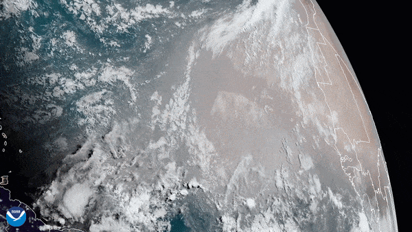
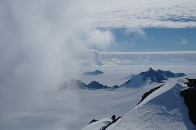
On June 16, 2020, the GOES-East satellite captured this GeoColor imagery of an expansive plume of dust from the Sahara Desert traveling westward across the Atlantic Ocean.
A “Godzilla dust cloud” from the Sahara Desert that’s heading toward the United States this week is the largest and most concentrated dust cloud of its kind in the past 50 years, according to news sources.
As of June 22, the dust cloud — which some experts have dubbed the “Godzilla dust cloud” — had reached the Caribbean, spiking air quality to “hazardous” levels, according to the AP. People along the Gulf Coast may be next to experience the dusty visitor.
Trade winds regularly carry dust clouds from the Sahara on a 5,000-mile (8,000 kilometers) journey across the Atlantic Ocean, but this particular formation “is an abnormally large dust cloud,” Dan Kottlowski, AccuWeather senior meteorologist and lead hurricane forecaster, told the weather website.
“One of the things I noticed from this is the dust started coming off the coast of Africa several days ago, in fact maybe over a week ago,” Kottlowski told AccuWeather. “And it’s still coming. It’s almost like a prolonged area of dust.”
The huge Saharan dust cloud formed June 13, when strong atmospheric updrafts over the Sahara were picked up by easterly winds, which blew the dust cloud west over the Atlantic, according to NASA.
Data collected by instruments aboard NASA’s Suomi National Polar-orbiting Partnership (NPP) satellite show the dust cloud’s enormity. Colin Seftor, an atmospheric scientist at NASA’s Goddard Space Flight Center in Greenbelt, Maryland, used that data to create an animation of the plume.
This animation shows the aerosols in the giant plume of Saharan Dust blowing off the western coast of Africa on June 13 through 18, 2020. (Image credit: NASA/NOAA, Colin Seftor)
“This is the most significant event in the past 50 years,” Pablo Méndez-Lázaro, an environmental health specialist at the University of Puerto Rico, told the AP. “Conditions are dangerous in many Caribbean islands,” including in Antigua and Trinidad & Tobago, he said.
Dust from the Sahara plays an important role on the other side of the Atlantic Ocean; it builds beaches in the Caribbean and fertilizes soil in the Amazon rainforest during June, July and sometimes early August, according to NASA. The current cloud, however, is also affecting air quality, prompting health officials to tell people to stay indoors and use air filters, the AP reported.
Saharan dust can also suppress tropical storms. “It keeps a lid on the atmosphere and brings dry air into anything that may try to develop, which is very detrimental for tropical development which relies on warm, moist air,” Alan Reppert, a senior meteorologist at AccuWeather told the site.
Image 1 of 3
On June 18, 2020, NASA-NOAA’s Suomi NPP satellite captured this visible image of the large light brown plume of Saharan dust over the North Atlantic Ocean. (Image credit: NASA Worldview)
Saharan dust plume, seen by the NOAA-20 satellite on June 17, 2020. (Image credit: NOAA)
This animation shows the aerosols in the giant plume of Saharan Dust blowing off the western coast of Africa on June 13 through 18, 2020. (Image credit: NASA/NOAA, Colin Seftor)
Even so, this cloud likely won’t affect the Atlantic hurricane season, which often peaks in August, September and October.
“Dust tends to be much less of a problem during the heart of the hurricane season,” Kottlowski told Acuweather.
To see a 10-day computer model forecast (as of June 22) of the dust cloud, check out this graphic tweeted by the National Weather Service.
The huge dust cloud will likely reach the Texas coast on Thursday (June 24) and cover the entire Gulf Coast by this weekend, Kottlowski said. The poor air quality this Saharan dust will bring could exacerbate the COVID-19 situation, according to an April study from the Netherlands. The study, published by the World Bank, suggests that areas with increased atmospheric particulate matter (that is, air pollution) have a higher incidence of the COVID-19 respiratory disease.
“The estimates suggest that expected COVID-19 cases increase by nearly 100% when pollution concentrations increase by 20%,” the researchers wrote in the study.
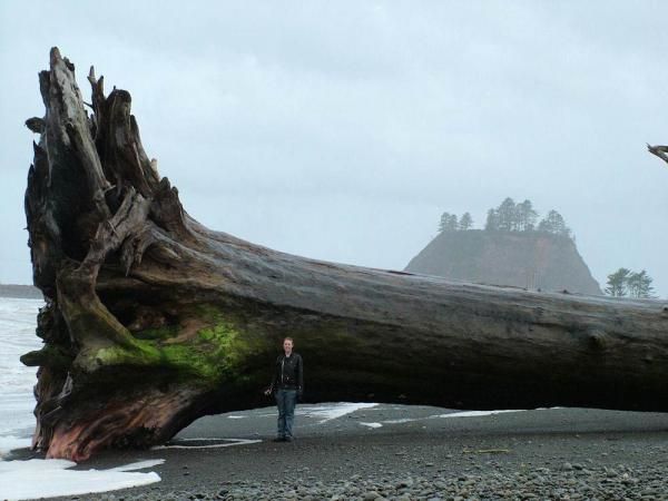
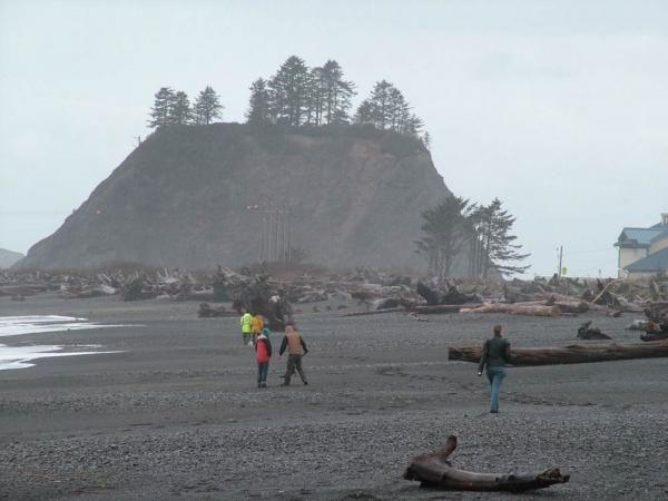
In a part of the country accustomed to towering trees, a massive piece of driftwood washed ashore recently in La Push, a small community on the northwest coast of Washington’s most westerly peninsula.
“It’s not uncommon to find one as tall as I am, but that’s pretty big,” said Barb Manse of Olympic National Park, which surrounds La Push.
This “piece” of driftwood is actually called a drift log. It wasn’t measured, but finding trees in the forest between 5 and 10 feet (1.5 and 3 meters) in diameter and a couple hundred feet tall isn’t uncommon, Manse said. [Photos: IMAX Showcases National Parks’ Astounding Beauty]
Powerful winds accompanied by high tides are required to bring these monsters ashore.
“We can get some huge winter storms that cause the rivers that flow through the forest to flood and trees on the edge can topple in,” Manse said.
The mountain slopes of the temperate rain forest that covers the Pacific Northwest rise quickly away from the La Push coast. When a strong gale blew though the community last spring, it toppled trees that then floated down rivers and washed up on the shore.
La Push shoreline strewn with drift wood. (Image credit: Phillip Lachman.)
“The wind was howling and there were rain squalls at times,” said Phillip Lachman, a retired school teacher who photographed the drift log on April 5, 2010. “On the beach at La Push there was a huge amount of driftwood of all sizes and there in the middle of the beach was this tree. We were mesmerized by the sheer size of it and wondered at the force of the wind that brought it here.”
Lachman’s daughter, Amanda, who is 6 ft (1.8 m) tall, is standing next to the drift log in the photograph he took.
Manse wasn’t able to identify the tree’s species, but she said Western red cedar, Douglas fir and Sitka spruce the signature tree of temperate rain forests are most common in the area.
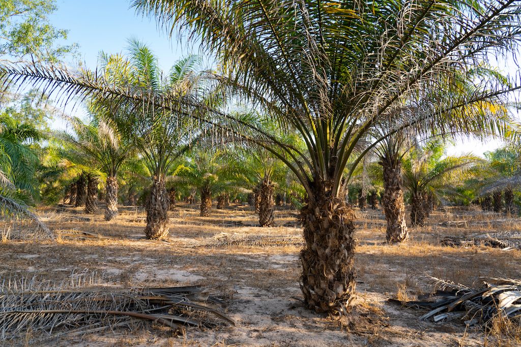
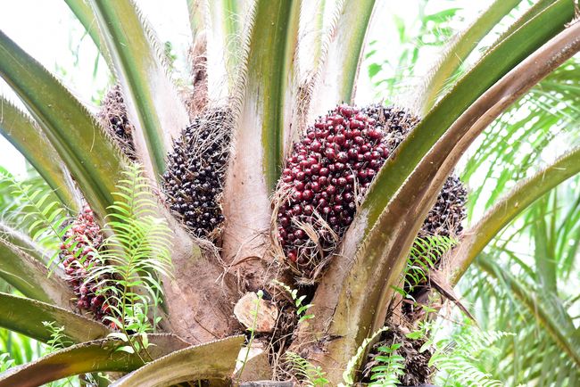
Palm oil is an edible vegetable oil that comes from the pulp of oil palm tree fruit. Native to West Africa, the oil palm tree is now most commonly grown in the tropics of Southeast Asia.
Palm oil is the most commonly produced vegetable oil in the world and is incorporated in a wide range of products, including many food items, cosmetics and biofuels. Worldwide annual production of the oil from 2018 to 2019 was nearly 81.6 million tons (71 million metric tons), according to the United States Department of Agriculture (USDA), and is expected to reach 264 million tons (240 million metric tons) by 2050, The Guardian reported in 2019. For reference, global annual production of soybean oil, the second most produced oil in the world, was about 63 million tons (57 million metric tons) from 2018 to 2019, according to the USDA.
The global market for palm oil grows with every passing year: By 2022, its worth is estimated to reach $88 billion, according to the World Health Organization. The biggest global suppliers of palm oil are Indonesia, followed by Malaysia. Combined, those countries produce approximately 85% of the world’s palm oil.
The production of palm oil is controversial, as oil palm plantations take the place of thousands of acres of mowed-down forests, making palm oil production one of the biggest drivers of deforestation. On the other hand, palm oil production provides jobs for millions of people and is an important natural resource in areas of the world with struggling economies.
Experts have estimated that palm oil can be found in about 50% of packaged items in the supermarket, according to the International Union for Conservation of Nature (IUCN). This includes everything from detergents to cosmetics to candy.
The attractiveness of palm oil to manufacturers lies in its cheap cost and versatility. It has a much higher production rate per hectare than any other vegetable oil, and it requires relatively small amounts of energy, fertilizer and pesticides to produce. Oil palm produces about 35% of all vegetable oil on less than 10% of the land allocated to oil-producing crops. To obtain the same amount of alternative oils, such as soybean or coconut oil, between four and 10 times more land would be required, according to the World Wildlife Fund (WWF).
Palm oil is the most common cooking oil in Asia, with India, China and Indonesia accounting for nearly 40% of all palm oil consumed worldwide. It’s a popular oil to cook with because of its high heat resistance, its long shelf life and, most importantly, its low price.
Palm oil is made from the pulp of oil palm fruit. Experts estimate that palm oil is in about 50% of all packaged items. (Image credit: Shutterstock)
Why is palm oil bad for the environment?
Palm oil production is seen as a path out of poverty for the populations of developing countries where it’s produced because it drives economic development. That trend has proliferated across the world; more palm oil plantations are beginning to pop up across Asia, Africa and Latin America. The palm oil industry employs as many as 3.5 million workers across Indonesia and Malaysia, according to a report by Humanity United.
However, the rapid expansion of oil palm plantations means that palm oil production is also a major contributor to large-scale deforestation. Industrial oil palm plantations have caused 56% of deforestation on the island of Borneo since 2005, according to a study in the journal Scientific Reports.
The increasing dedication of land once occupied by tropical forests and other species-rich habitats to palm oil plantations has made palm oil production a major threat to biodiversity. The expansion of plantations has led to the increasingly serious risk of extinction for the orangutan, the pygmy elephant and the Sumatran rhino. The production of palm oil affects at least 193 threatened species, according to The IUCN Red List of Threatened Species.
Palm oil plantations are also a huge source of greenhouse gas emissions. Because they are typically established on land converted from swamp forests, clearing the land releases large amounts of carbon dioxide and methane. The most common method of clearing is by incineration, or so-called “slash-and-burn practices,” which also contribute to regional smoke haze and water pollution.
The wastewater from palm oil refineries is another huge source of methane. A study published in the journal Nature Climate Change showed that the methane produced by a single pond of palm refinery wastewater has the same annual climate impact as 22,000 cars.
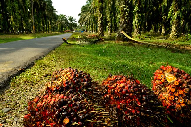
Road by a palm oil plantation where a forest used to be, in Sumatra, Indonesia. Palm oil production is a major driver of deforestation. (Image credit: Shutterstock)
Can palm oil ever be sustainable?
Environmentally conscious consumers might think that boycotting products containing palm oil — either by not purchasing them or by putting pressure on retailers to forego it — is the best route toward eliminating the environmental damage caused by palm oil plantations. But it’s not as simple as that.
If palm oil use were restricted, it would need to be replaced by other types of vegetable oils in order to meet the global demand for it. However, there is no equal alternative. Other oils such as rapeseed, sunflower and soybean are nowhere near as efficient to produce as palm. In 2018, the IUCN released a report that described how boycotting palm oil would simply shift the crop’s biodiversity impacts to regions where its replacement oils are produced, such as the tropical forests and savannas of South America.
“If you’re shifting demand to a less efficient oil, you’re going to need more land, and more land comes at the expense of the natural habitats that we all cherish and love across the world,” said Matthew Struebig, a tropical conservation scientist at the University of Kent in the United Kingdom.
Our best hope for decreasing the environmental impacts of palm oil is to strive “for more sustainable production,” Struebig told Live Science. And that means more than just eliminating the threat to endangered species.
“Sustainability is much broader than just species protection. It’s about people’s livelihoods; it’s about their well-being; it’s about greenhouse gas emissions; it’s about clean, healthy water; it’s about having access to a decent wage,” he said. “The issues that are there are much broader than orangutans.”
As of 2020, just under 20% of palm oil is sustainably produced, according to the Roundtable on Sustainable Palm Oil (RSPO), a global initiative formed in 2004 that sets specific standards regarding deforestation, lawfulness, transparency and social impact — standards that must be met in order for palm oil to be considered sustainably derived. Companies such as PepsiCo, Unilever, Nestlé and General Mills have made the commitment to source 100% RSPO-certified sustainable palm oil.
Several nonprofit groups are also working toward a more sustainable palm oil industry in countries where millions are dependent on its continued existence. For example, an initiative based in Malaysia called Wild Asia is helping to organize hundreds of small farmers into larger groups that can be certified to sell palm fruit that meets the requirements of the Malaysian Sustainable Palm Oil (MSPO) and RSPO Production standard, so it benefits both the farmers and the environment.
Palm oil isn’t going away anytime soon. So, the most effective way to curb the environmental impacts of palm oil is to support the initiatives and brands committed to a more sustainable palm oil industry.
(Image credit: George Gentry | U.S. Fish and Wildlife Service)
Birds of prey, including hawks, falcons, owls and eagles, such as the bald eagle above, are also known as raptors because they use their claws instead of their beaks to capture prey. They are meat-eaters with keen eyesight, easily able to spot small prey as they soar through the sky.
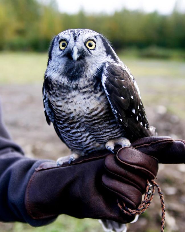
Northern Hawk Owl
(Image credit: Ronald Laubenstein | U.S. Fish and Wildlife Service )
Although owls are known for being nocturnal, the above Northern hawk owl (Surnia ulula) mainly hunts during the day. The owl gets its name from its relatively flat head, long tail and hawk-like flight pattern, according to the Minnesota Department of Natural Resources.
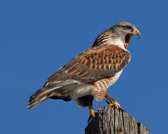
Ferruginous Hawk
(Image credit: U.S. Fish and Wildlife Service )
Ferruginous hawks (Buteo regalis) can be found in southwestern Canada, the western United States, and northern Mexico. Like most birds of prey, it mostly hunts small mammals, including rabbits, prairie dogs, gophers, mice and ground squirrels, but it can also eat smaller birds, fish, amphibians, reptiles and insects.
Sharp-Shinned Hawk
(Image credit: Mike Morel | U.S. Fish and Wildlife Service )
The Puerto Rican sharp-shinned hawk (Accipiter striatus venator) is a small forest hawk that grows to approximately 11 to 13 inches (28 to 33 centimeters) in length. It mostly feeds on even smaller birds, including quail, multi-colored tanagers and hummingbirds.
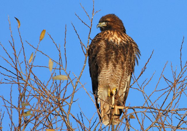
Red-tailed Hawk
(Image credit: U.S. Fish and Wildlife Service )
The red-tailed hawk, known as Buteo jamaicensis due to the original sighting of the bird in Jamaica, is the most common hawk in the United States. These hawks are monogamous and can mate for life, usually staying with their partner until one of them dies.
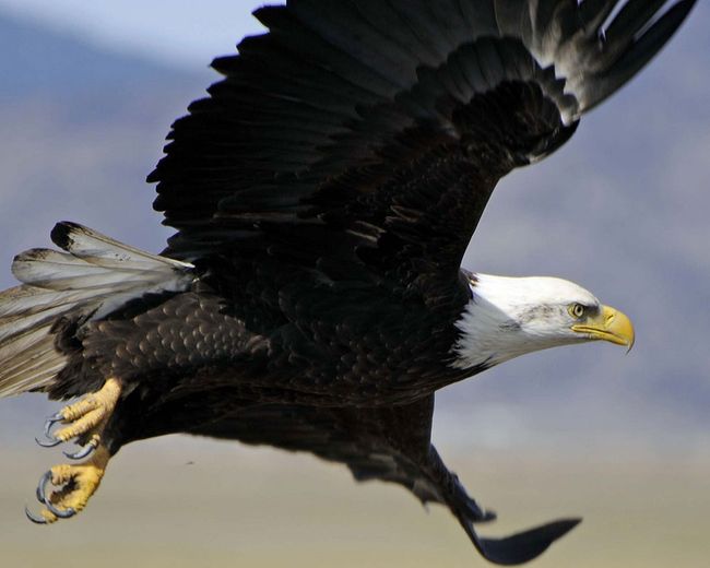
Bald Eagle
(Image credit: Steve Hillebrand | U.S. Fish and Wildlife Service)
Bald eagles soar at an altitude of 10,000 feet (3,048 meters), reaching speeds of about 30 to 35 miles per hour. They are also very good swimmers, which comes in handy when they are hunting for fish. Keeping with its status as the U.S. national emblem, the bald eagle can be found in every state except Hawaii.
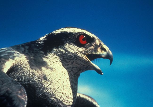
Goshawk
(Image credit: W.M. Smith | U.S. Fish and Wildlife Service )
The goshawk (Accipiter gentilis) typically lives in heavily wooded forests throughout North America, Europe and Asia. Like the Puerto Rican sharp-shinned hawk, the goshawk mainly hunts other birds. It also eats woodland mammals, and can hunt prey as large as hares and foxes.
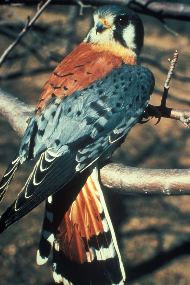
American Kestrel
(Image credit: Dave Menke | U.S. Fish and Wildlife Service )
The American kestrel (Falco sparverius) is a small falcon and has dark marks framing its eyes, which are characteristic of falcons. It prefers to dwell near open fields, where it can perch tall trees and watch for prey such as insects and reptiles in the grass below.
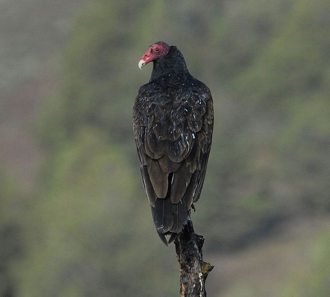
Turkey Vultures
(Image credit: U.S. Fish and Wildlife Service )
Also known as turkey buzzards, turkey vultures (Cathartes aura) are the only birds of prey that mainly feed on carcasses and carrion, which are the meaty remains leftover by other animals. They possess a keen sense of smell, and like many other vultures, the turkey vulture has a bald head. Theturkey vulture’s name comes from its red, featherless head, which resembled that of a turkey.
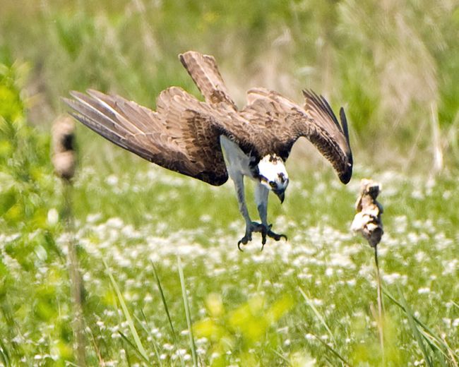
Osprey
(Image credit: George Gentry | U.S. Fish and Wildlife Service )
Like other birds of prey, the osprey (Pandion haliaetus) has sharp, rounded talons for grasping its prey. What makes it unique is that the osprey is the only raptor with a reversible outer toe, which allows it to grab prey with two front talons as well as its two back toes. Also known as sea hawks, ospreys can be found on all continents except Antarctica. The above Osprey is diving close to the ground in pursuit of its prey.
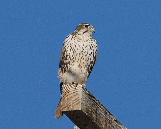
Prairie Falcon
(Image credit: U.S. Fish and Wildlife Service )
The prairie falcon (Falco mexicanus) can be found in western North America as well as southwestern Canada. This falcon searches for prey, which includes ground squirrels, small birds, reptiles and insects, during the daytime.
Harpy Eagle
(Image credit: Hotshotsworldwide | Dreamstime)
With a 6.5-foot wingspan, the harpy eagle is one of the world’s largest eagles. In fact, its hind talons rival grizzly bear claws in size. Its scientific name, Harpia harpyja, stems from the Greek word “harpe,” which Aristotle and other Greek scholars used to describe birds of prey. Mythological “harpies” had a bird’s body, fearsome claws and a woman’s face.
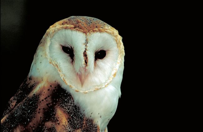
Barn Owl
(Image credit: Thomas G. Barnes | U.S. Fish and Wildlife Service )
Like the osprey, the barn owl (Tyto alba) is found on all continents except Antarctica. It prefers to live near grassy fields and meadows, where it hunts mice, bats and even skunks. Its white face is framed by a heart-shaped facial disk, and its tawny body is flecked with small black-and-white spots. The barn owl doesn’t make the expected “hoot” sound, instead producing a high-pitched scream that sounds like a screeching cat.
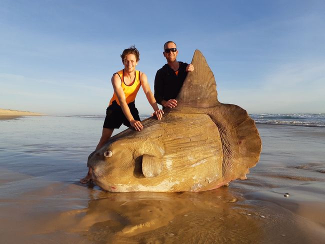
When a group of Aussies spotted the behemoth on the beach, they initially thought it was a rugged piece of driftwood. Upon closer inspection, however, they realized it was the body of an enormous, bony fish.
That’s how they came face to face with the mighty ocean sunfish, known to scientists as the Mola mola. These fish can grow up to 11 feet (3.3 meters) long and weigh up to 2.5 tons (2.2 metric tons), according to National Geographic.
Linette Grzelak, whose partner, Steven Jones, sent her a photo of the dead fish, related that he “said it was extremely heavy and the skin felt hard and leathery like a rhinoceros.” [In Photos: The World’s Largest Bony Fish]
Jones is a supervisor of a cockle-fishing crew, which drives that stretch of beach for work. “I’m always getting sent photos of what they find, but it’s mostly sharks and seals,” Grzelak told Live Science. “Saturday night [March 16], I got sent the sunfish and thought it was fake. I had no idea what it was.”
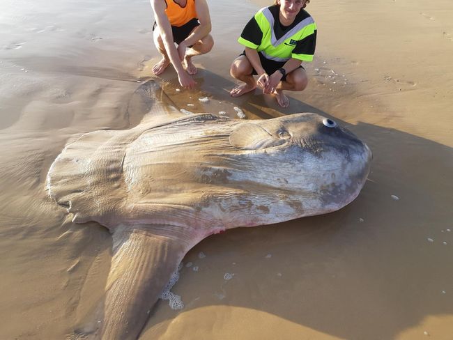
Ocean sunfish are among the largest known bony fish in the world. (Image credit: Linette Grzelak)
These fish are rarely seen in that neck of the woods, in South Australia at the mouth of the Murray River, which is the longest river in Australia. But M. mola fish have a wide range; they’re known to live all over the world, mostly in temperate and tropical waters.
Despite their size, ocean sunfish do not prey on humans. Instead, they feast on small and soft animals, like jellyfish and zooplankton, according to a 2010 study in the journal Reviews in Fish Biology and Fisheries. However, Jones said he “has heard stories over the years about sunfish sinking yachts in races and the damage they do to boats,” Grzelak noted.
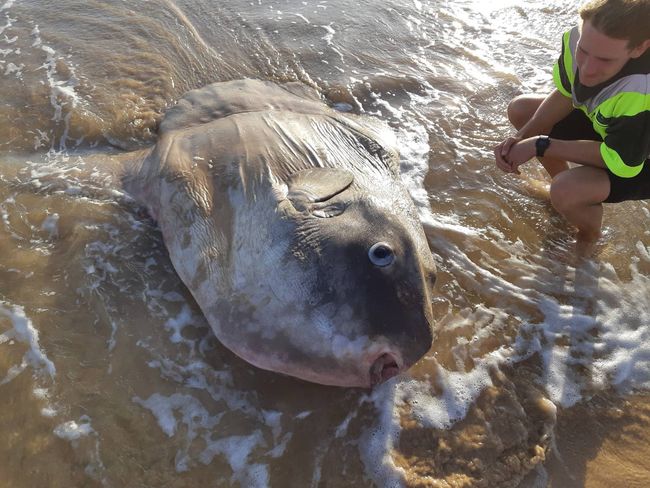
In addition to their impressive dimensions, ocean sunfish are recognizable for their wide eyes, which make them look like they’re constantly startled, and their tall fins are often mistaken for those of sharks when they breach the water’s surface, according to Two Oceans Aquarium in Cape Town, South Africa. In addition, they lack a true tail, researchers reported in 2008 in the journal PLOS One.
Though enormous, these fish pose no danger to humans. Rather, they eat jellyfish and zooplankton. (Image credit: Linette Grzelak)
After the cockle-fishing crew found the sunfish, they took photos that were later posted to iNaturalist, a crowdsourcing site that scientists use to identify species. The consensus was that the fish was an ocean sunfish.
However, the fish is now lost to the sea. The crew didn’t have time to save the deceased animal’s body, because they were working. Moreover, that stretch of beach is accessible only by boat, is a low-traffic site that is mainly visited only by fisheries and doesn’t have cellphone reception. So, the team couldn’t call anyone to collect the fish before it was washed back to sea by the tide, Grzelak said.
Given that there weren’t any visible signs of damage on the fish, “there is the assumption that it died of either natural causes, eating too much plastic or parasites,” according to scientists who consulted with the team about the fish, Grzelak said.
Another species of sunfish made the news a few weeks ago, too; a hoodwinker sunfish (Mola tecta), a species discovered by scientists in 2017, washed ashore near Santa Barbara, California, thousands of miles from its known home in the Southern Hemisphere.
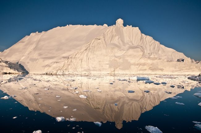
The midnight sun glows off an iceberg in Disko Bay, Greenland. Icebergs calving into the sea are a major source of Greenland’s ice loss.
Meltwater Stream
(Image credit: Ian Joughin)
A stream of meltwater flows across the ice surface in Greenland.
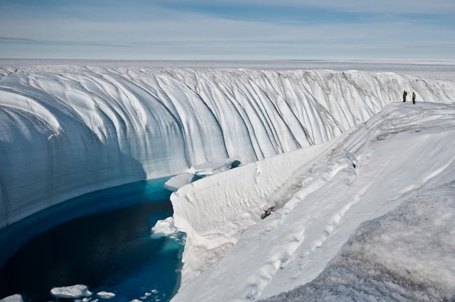
Ice Canyon
(Image credit: Ian Joughin)
Meltwater creates a 60-foot deep (18.2 meter) canyon in the polar ice sheet.
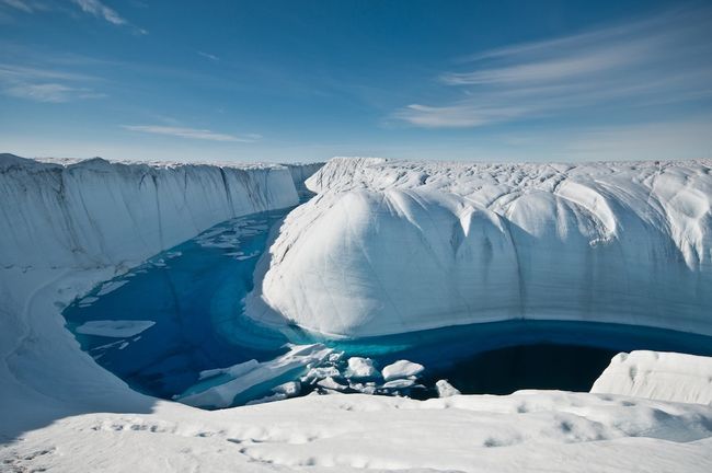
Meltwater Conduit
(Image credit: Ian Joughin)
This canyon drained a large meltwater lake on the surface of the ice into a moulin, or under-ice channel that flows to the bottom of the ice sheet.
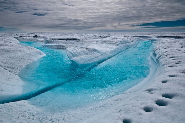
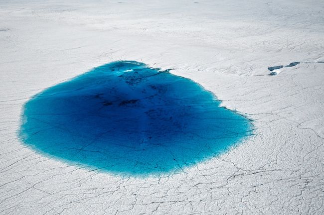
Glacial Lake
(Image credit: Ian Joughin)
Supraglacial lakes like this one (which is about 0.75 miles in diameter) dot the surface of the Greenland ice sheet during the summer seasonal melt.
Moulin
(Image credit: Ian Joughin)
A moulin dips into the ice sheet, channeling water to the base of the ice, where a network of underground springs route it to the sea.
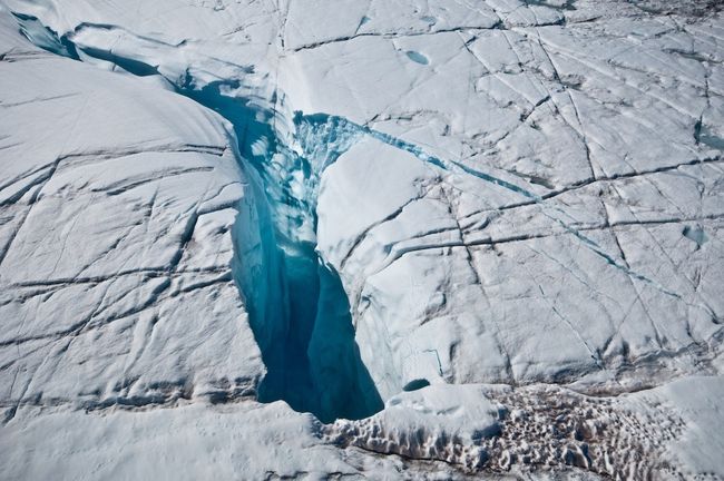
Pine Island Glacier
(Image credit: Ian Joughin)
Crevasses mar stretching ice on the Pine Island Glacier in Antarctica.
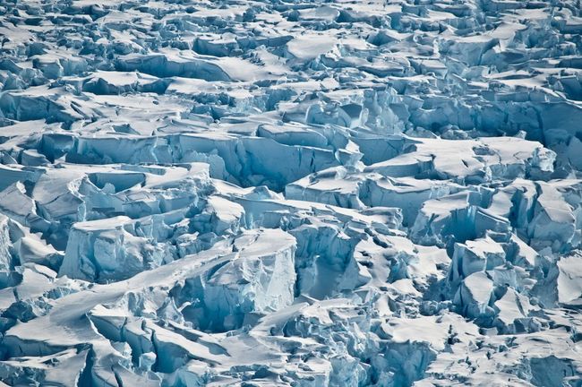
Pine Island Glacier Flow
(Image credit: Ian Joughin)
Crevasses reveal the slow movement of the Pine Island Glacier in Antarctica.
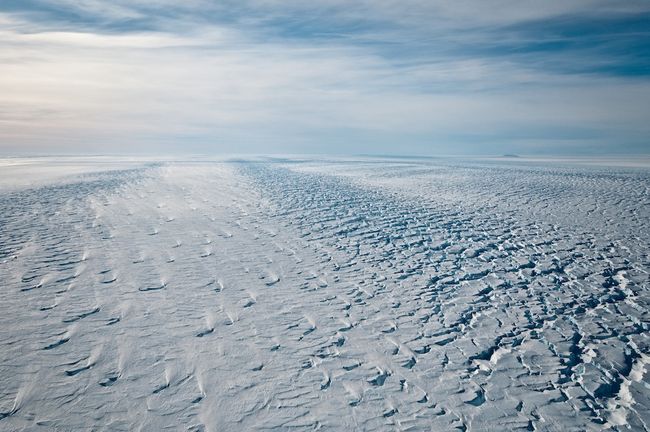
Criss-Crossing Crevasses
(Image credit: Ian Joughin)
Criss-Crossing Crevasses near the grounding line of the Pine Island Glacier, where the glacier meets Antarctica’s sea ice.
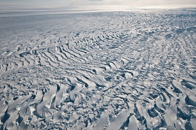
Aerial Glacier View
(Image credit: Ian Joughin)
An aerial view of the Pine Island Glacier in Antarctica, looking seaward.
Staccato Peaks
(Image credit: Ian Joughin)
The Staccato Peaks of Alexander Island on the Antarctic Peninsula. Complex weather and snowfall in this region makes assessing ice loss and gain difficult.
These Stunning 3D Images Reveal How a Massive Greenland Glacier Has Changed
By Jeanna Bryner, Live Science Managing Editor | August 2, 2017 10:25am ET
Watching a glacier
Credit: Jefferson Beck/NASA Goddard
NASA scientists are keeping sharp eyes on Greenland’s glaciers. Such gazing reveals more than the beauty of this unique and massive, icy island. The scientists, part of NASA’s Operation IceBridge, are conducting airborne surveys to find out how the glaciers are changing over time.
Glacier surface
Credit: Jefferson Beck/NASA Goddard
Laser altimeters can map the teensy details of the surfaces of these Greenland glaciers. NASA uses two laser altimeters: One is optimized for low altitude and the other for medium altitude, they said.
Laser altimetry
Credit: Jefferson Beck/NASA Goddard
The laser altimeter measurements show elevation changes on the glacier surface.
Helheim Glacier
Credit: Jefferson Beck/NASA Goddard
“On Greenland’s rugged eastern coast, spilling into a mountainous fjord, lies the 4-mile-wide Helheim Glacier, named for the Viking world of the dead,” NASA says in the video.
Dramatic changes
Credit: Jefferson Beck/NASA Goddard
“Flights spanning two decades reveal the dramatic changes that have taken place,” NASA said on a video about the mission.
Rapid retreat
Credit: Jefferson Beck/NASA Goddard
Here, the glacier is shown after a rapid retreat and thinning episode.
Partial recovery
Credit: Jefferson Beck/NASA Goddard
Following the retreat, the glacier partially recovered its former extent.
Helheim in 2001
Credit: Jefferson Beck/NASA Goddard
NASA missions have flown along the center line of the glacier year after year. Here, the extent of the Helheim Glacier is shown in 2001 from NASA Operation IceBridge surveys.
Helheim in 2007
Credit: Jefferson Beck/NASA Goddard
The extent of the Helheim Glacier is shown in 2007 from NASA Operation IceBridge surveys.
Helheim extent
Credit: Jefferson Beck/NASA Goddard
The extent of the Helheim Glacier is shown in 2011 from NASA Operation IceBridge surveys.
Helheim in 2014
Credit: Jefferson Beck/NASA Goddard
The extent of the Helheim Glacier is shown in 2014 from NASA Operation IceBridge surveys.
Firing laser pulses
Credit: Jefferson Beck/NASA Goddard
With laser altimetry, laser instruments on board the research aircraft fire several thousand pulses of light every second. The results reveal the height of the surface below.
Spinning swath
Credit: Jefferson Beck/NASA Goddard
The lasers spin in a circle that’s 820 feet (250 meters) across, which provides a swath of data that an be transformed into a topographic map of the ice, NASA said.
Elevation changes
Credit: Jefferson Beck/NASA Goddard
Here, higher elevations on the glacier are shown in red and orange, while lower elevations are in green and blue.
1998 calving event
Credit: Jefferson Beck/NASA Goddard
The laser altimeters showed height measurements all the way down to the Helheim Glacier’s calving front, where icebergs break off into the sea.
Icebergs break off
Credit: Jefferson Beck/NASA Goddard
Here’s a 1998 swath compared with one from 2013. In this image, the color scale is changed to show the local differences in elevation, according to NASA.
Retreat
Credit: Jefferson Beck/NASA Goddard
The 2013 swath from the laser altimeters reveals that the calving front retreated significantly since 1998, by 2.5 miles (4 kilometers), according to the NASA video.
Gorgeous mosaic
Credit: Jefferson Beck/NASA Goddard
NASA’s Operation IceBridge mission has also used a high-resolution camera system to take overlapping images of the ice of Helheim Glacier throughout its 8-hour flights. These images can then be pieced together into a mosaic.
Stereoscopic view
Credit: Jefferson Beck/NASA Goddard
Because the images overlap, they can provide scientists with a stereoscopic view of the ice and even elevation measurements. The NASA scientists overlaid the elevation information from the images on top of the measurements from the laser altimetry.
Steep calving front
Credit: Jefferson Beck/NASA Goddard
Helheim’s calving front, which is 70 feet (21 meters) high, can be seen here.
Springtime flights
Credit: Jefferson Beck/NASA Goddard
Until the launch of a new NASA satellite called ICESat-2, the Operation IceBridge mission will return to Greenland every spring to continue monitoring the glacier, NASA said.
This visualization shows the rhythm of global warming for countries around the world.
Credit: climatecentraldotorg/YouTube
Last year, there was the temperature spiral. This year, it’s the temperature circle that’s making the trend of global warming crystal clear.
A new video shows the rhythm of global warming for countries around the world, from Afghanistan to Zimbabwe. Bars representing each country’s annual average temperature anomaly pulse up and down. It’s like watching a heartbeat on a monitor.
Rather than staying steady like a normal heartbeat, it’s clear that temperatures for more than 100 countries are climbing ever higher on the back of increasing carbon pollution. While there are individual variations in how hot any year is, the signal of climate change is unmistakable.
“There are no single countries that clearly stand out from the graph,” saidAntti Lipponen, a physicist at the Finnish Meteorological Institute who made the graphic. “The warming really is global, not local.”
While the temperature spiral showed the global average temperature, Lipponen’s animation uses NASA data to show individual countries separated by regions. The format invites you to look for your country or the place you took your vacation last year.
But step back to look at the graphic as a whole and it’s clear we’re all in this together. No country is immune from rising temperatures, let alone the other impacts of climate change.
It’s also clear that global warming is accelerating. In the past three decades (which starts around the 14-second mark in the video), the bars start pushing further and further from the center. Cooler-than-normal years start to become more rare and by the 1990s, they’ve almost disappeared completely.
The past three years have been the hottest ones ever recorded. A number of countries were more than 2 degrees Celsius warmer than the 1951-1980 baseline used in the graphic. That puts them well above the warming limitenshrined in the Paris Agreement, serving as a warning of how fast we’re pushing into new territory.
The world itself touched 1.5 degrees Celsius above pre-industrial levels for a few months in 2016. If global warming permanently crosses that threshold, it will likely cause small island states to be swallowed by the sea, coral to die and heat waves to become more common and severe.
Those numbers alone are abstract, though. Even plotted on a line graph, they fail to fully convey the trajectory we’re on.
Lipponen said he made the animation because he wanted a “nice looking, clear, and informative” way to convey that information in a way people can understand. Mission accomplished.
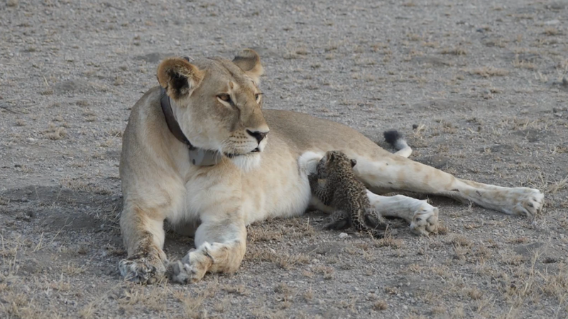
Earlier this week, a remarkable scene played out at Tanzania’s Ngorongoro Conservation Area. An orphaned leopard cub, desperate for a meal, approached a lioness who happened to be lactating. It’s a rare—and extremely precious—example of cross-species nursing in the wild.
“This is a truly unique case,” noted Luke Hunter, the president of Panthera, at the organization’s blog. “I know of no other example of inter-species adoption or nursing like this among big cats in the wild. This lioness is known to have recently given birth to her own cubs, which is a critical factor. She is physiologically primed to take care of baby cats, and the little leopard fits the bill—it is almost exactly the age of her own cubs and physically very similar to them.”
Hunter says Nosikitok, who’s wearing a GPS collar for tracking purposes, wouldn’t be nursing the cub if she “wasn’t already awash with a ferocious maternal drive,” which he says is typical of lionesses.
“Even so, there has never been another case like it, and why it has occurred now is mystifying. It is quite possible she has lost her own cubs, and found the leopard cub in her bereaved state when she would be particularly vulnerable,” he wrote.
It seems like a match made in heaven, except that it probably isn’t. The leopard cub’s future prospects look bleak, according to Hunter. “The natural odds are stacked against this little fellow,” he told AP, saying the cub will likely be killed by other lions who don’t recognize it as one of their own. And in fact, the cub was nowhere to be seen the day after the pictures were taken.
“In order for the [cross-species] relationship to be sustained, I believe both parties will need to benefit in some way,” said Jill Goldman, an applied animal behaviorist, in aninterview with National Geographic. “How we define benefit is another matter. Social companionship in some cases may actually be enough of a benefit so long as it is not outweighed by competition [or] threat.”
In this case, an orphaned cub being accepted by a potentially grieving lioness, it sure seems possible there’s some “mutual benefit” going on.
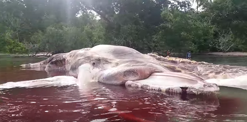
While many of us envisioned the world going out in a wicked blaze of glory, sadly, that doesn’t seem to be the way things will go. Instead, we have to settle for Ted Cruz, the other horsemen of the apocalypse, and this massive beast that just washed up on the shore of Indonesia’s Maluku province.
In a series of unnerving YouTube videos, local Patasiwa Kumbang Amalatu has detailed the decay of what looks like a liopleurodon wrapped in very old skin. In one of the videos, Amalatu postulates that this is a humpback whale covered in its own decomposing flesh, according to Vice.
“This is a humpback whale,” he said. “These aren’t tusks. This is its mouth, but it’s covered with decomposed skin.”
A Facebook video posted by the Indonesian army, meanwhile, declares the rotting sea creature to be a giant squid. But a museum officer at the Lee Kong Chian Natural History Museum agreed with Amalatu, telling Mashable that the carcass is probably a baleen whale.
In another video, ostensibly taken later, the skin-beast looks darker and more decayed. Obviously, it’s nightmare fuel:
While there’s no official confirmation on what this thing is or who’s going to take it out of the water, one thing’s for sure: as signs of the End Times go, it can’t be worse than this.